Caledonia, Missouri facts for kids
Quick facts for kids
Caledonia, Missouri
|
|
|---|---|
|
Village
|
|
| Nickname(s):
Caley
|
|

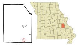
Location of Caledonia, Missouri
|
|
| Country | United States |
| State | Missouri |
| County | Washington |
| Area | |
| • Total | 0.16 sq mi (0.42 km2) |
| • Land | 0.16 sq mi (0.42 km2) |
| • Water | 0.00 sq mi (0.00 km2) |
| Elevation | 902 ft (275 m) |
| Population
(2020)
|
|
| • Total | 131 |
| • Density | 798.78/sq mi (308.71/km2) |
| Time zone | UTC-6 (Central (CST)) |
| • Summer (DST) | UTC-5 (CDT) |
| ZIP code |
63631
|
| Area code(s) | 573 |
| FIPS code | 29-10432 |
| GNIS feature ID | 2397530 |
Caledonia is a small village in southern Washington County, Missouri, in the United States. In 2020, about 131 people lived there. Caledonia is located about 4 miles east of Belgrade.
Contents
History of Caledonia
Caledonia was planned and built in 1819. The village got its name from the Roman Empire's Latin name for Scotland. A post office has been open in Caledonia since 1819, helping people send and receive mail for a very long time.
Some important historical places in Caledonia are listed on the National Register of Historic Places. This means they are special and protected because of their history. These places include the Caledonia Historic District, the Land Archeological Site, the Lost Creek Pictograph Archeological Site, and the Harrison Queen House.
Geography of Caledonia
Caledonia is found where two main roads meet: Missouri Route 32 and Missouri Route 21. A stream called Goose Creek flows right through the village. Spring Glen Lake is also nearby, about one mile northeast along Goose Creek.
The village covers a total area of about 0.16 square miles (0.42 square kilometers). All of this area is land, with no large bodies of water inside the village limits.
Caledonia's Population Over Time
| Historical population | |||
|---|---|---|---|
| Census | Pop. | %± | |
| 1880 | 236 | — | |
| 1900 | 166 | — | |
| 1910 | 128 | −22.9% | |
| 1920 | 133 | 3.9% | |
| 1930 | 143 | 7.5% | |
| 1940 | 139 | −2.8% | |
| 1950 | 143 | 2.9% | |
| 1960 | 119 | −16.8% | |
| 1970 | 113 | −5.0% | |
| 1980 | 162 | 43.4% | |
| 1990 | 142 | −12.3% | |
| 2000 | 158 | 11.3% | |
| 2010 | 130 | −17.7% | |
| 2020 | 131 | 0.8% | |
| U.S. Decennial Census | |||
Population in 2010
In 2010, the village had 130 people living there. There were 58 households, which are groups of people living together. The population density was about 812 people per square mile.
Schools in Caledonia
The local school district is called Valley R-VI. Their mascot is the Viking! The district has two sets of buildings for students. One set is for elementary school (kindergarten through 6th grade). The other set is for junior high and high school (7th through 12th grade).
The elementary school buildings have a unique dome shape. These unusual structures are built to be very strong. They can stand up to severe weather like tornadoes and hurricanes. They are also fireproof, which helps keep the students safe.
Nearest Airport
The closest airport to Caledonia is the Washington County Airport. It is located on Airport Road in Mineral Point, Missouri.
See also
 In Spanish: Caledonia (Misuri) para niños
 | Delilah Pierce |
 | Gordon Parks |
 | Augusta Savage |
 | Charles Ethan Porter |

