Calhoun, Louisiana facts for kids
Quick facts for kids
Calhoun, Louisiana
|
|
|---|---|

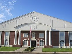
First Baptist Church of Calhoun
|
|
| Country | |
| State | |
| Parish | Ouachita |
| Area | |
| • Total | 2.36 sq mi (6.12 km2) |
| • Land | 2.36 sq mi (6.12 km2) |
| • Water | 0.00 sq mi (0.00 km2) |
| Elevation | 100 ft (30 m) |
| Population
(2020)
|
|
| • Total | 670 |
| • Density | 283.66/sq mi (109.54/km2) |
| Time zone | UTC-6 (Central (CST)) |
| • Summer (DST) | UTC-5 (CDT) |
| ZIP code |
71225
|
| Area code(s) | 318 |
| FIPS code | 22-11825 |
Calhoun is a small community in Ouachita Parish, Louisiana, United States. It is called an "unincorporated community" because it does not have its own local city government. Instead, it is managed by the parish, which is like a county. Calhoun is also a "census-designated place," meaning the U.S. Census Bureau counts its population separately.
The community is named after Archibald Calhoun, one of its first settlers and landowners. Calhoun is located about 10 miles west of West Monroe. It sits in a countryside area with hills and forests. It is near the old U.S. 80 highway and Interstate 20.
Calhoun has grown quite a bit recently. Many new shops, restaurants, and fun places have opened nearby. There are also three universities in the area. This makes Calhoun a popular spot for young families. The community has four public schools that are known for their high achievements.
Contents
Famous People from Calhoun
Several notable people have connections to Calhoun.
- Newt V. Mills, a former U.S. Representative for Louisiana, was born here.
- James M. Goslin, who served as Sheriff of Caddo Parish, was also born in Calhoun.
- Ken Coon, a former chairman for the Republican Party in Arkansas, grew up in Calhoun.
- Zach Dasher, who ran for a seat in the U.S. Congress for Louisiana's 5th congressional district, lives in Calhoun.
Population and People
This section shares information about the number of people living in Calhoun.
| Historical population | |||
|---|---|---|---|
| Census | Pop. | %± | |
| 2020 | 670 | — | |
| U.S. Decennial Census | |||
Calhoun's Population in 2020
The 2020 United States census counted 670 people living in Calhoun. These people lived in 135 households, with 121 of them being families.
The table below shows the different groups of people living in Calhoun in 2020. This is called the "racial composition" of the community.
| Group | Number of People | Percentage |
|---|---|---|
| White (not Hispanic or Latino) | 569 | 84.93% |
| Black or African American (not Hispanic or Latino) | 40 | 5.97% |
| Native American | 4 | 0.6% |
| Asian | 2 | 0.3% |
| Other/Mixed (two or more races) | 30 | 4.48% |
| Hispanic or Latino | 25 | 3.73% |
Weather in Calhoun
Calhoun has a type of weather called a humid subtropical climate. This means it has hot, humid summers and mild winters.
The hottest temperature ever recorded in Calhoun was 110 °F (43 °C). This happened on August 18, 1909, and again on September 1, 2000. The coldest temperature ever recorded was -13 °F (-25 °C) in February 1899.
| Climate data for Calhoun, Louisiana, 1991–2020 normals, extremes 1892–2022 | |||||||||||||
|---|---|---|---|---|---|---|---|---|---|---|---|---|---|
| Month | Jan | Feb | Mar | Apr | May | Jun | Jul | Aug | Sep | Oct | Nov | Dec | Year |
| Record high °F (°C) | 85 (29) |
90 (32) |
94 (34) |
98 (37) |
100 (38) |
109 (43) |
109 (43) |
110 (43) |
110 (43) |
100 (38) |
90 (32) |
87 (31) |
110 (43) |
| Mean maximum °F (°C) | 75.6 (24.2) |
78.7 (25.9) |
83.9 (28.8) |
87.5 (30.8) |
91.4 (33.0) |
96.2 (35.7) |
99.4 (37.4) |
100.7 (38.2) |
97.2 (36.2) |
90.4 (32.4) |
82.9 (28.3) |
76.7 (24.8) |
101.6 (38.7) |
| Mean daily maximum °F (°C) | 56.8 (13.8) |
61.1 (16.2) |
68.9 (20.5) |
76.4 (24.7) |
83.4 (28.6) |
90.3 (32.4) |
93.2 (34.0) |
93.6 (34.2) |
88.7 (31.5) |
78.2 (25.7) |
67.2 (19.6) |
59.2 (15.1) |
76.4 (24.7) |
| Daily mean °F (°C) | 44.8 (7.1) |
48.3 (9.1) |
56.0 (13.3) |
63.2 (17.3) |
71.4 (21.9) |
78.5 (25.8) |
81.6 (27.6) |
81.3 (27.4) |
75.7 (24.3) |
64.0 (17.8) |
53.9 (12.2) |
46.8 (8.2) |
63.8 (17.7) |
| Mean daily minimum °F (°C) | 32.8 (0.4) |
35.5 (1.9) |
43.0 (6.1) |
50.0 (10.0) |
59.3 (15.2) |
66.7 (19.3) |
70.0 (21.1) |
69.0 (20.6) |
62.7 (17.1) |
49.9 (9.9) |
40.5 (4.7) |
34.5 (1.4) |
51.2 (10.6) |
| Mean minimum °F (°C) | 17.6 (−8.0) |
22.2 (−5.4) |
26.9 (−2.8) |
33.9 (1.1) |
45.8 (7.7) |
57.4 (14.1) |
63.8 (17.7) |
62.0 (16.7) |
47.7 (8.7) |
34.8 (1.6) |
26.5 (−3.1) |
19.5 (−6.9) |
14.6 (−9.7) |
| Record low °F (°C) | −2 (−19) |
−13 (−25) |
14 (−10) |
26 (−3) |
34 (1) |
45 (7) |
52 (11) |
44 (7) |
36 (2) |
24 (−4) |
10 (−12) |
5 (−15) |
−13 (−25) |
| Average precipitation inches (mm) | 5.70 (145) |
4.98 (126) |
5.47 (139) |
5.69 (145) |
5.39 (137) |
4.36 (111) |
4.01 (102) |
3.51 (89) |
3.58 (91) |
4.66 (118) |
4.71 (120) |
5.50 (140) |
57.56 (1,463) |
| Average snowfall inches (cm) | 0.1 (0.25) |
0.0 (0.0) |
0.0 (0.0) |
0.0 (0.0) |
0.0 (0.0) |
0.0 (0.0) |
0.0 (0.0) |
0.0 (0.0) |
0.0 (0.0) |
0.0 (0.0) |
0.0 (0.0) |
0.0 (0.0) |
0.1 (0.25) |
| Average precipitation days (≥ 0.01 in) | 9.3 | 8.6 | 9.0 | 7.4 | 8.1 | 8.6 | 7.7 | 6.3 | 6.1 | 6.8 | 8.0 | 8.7 | 94.6 |
| Average snowy days (≥ 0.1 in) | 0.0 | 0.1 | 0.0 | 0.0 | 0.0 | 0.0 | 0.0 | 0.0 | 0.0 | 0.0 | 0.0 | 0.1 | 0.2 |
| Source 1: NOAA | |||||||||||||
| Source 2: National Weather Service (mean maxima/minima 1981–2010) | |||||||||||||
See also
 In Spanish: Calhoun (Luisiana) para niños
 | Roy Wilkins |
 | John Lewis |
 | Linda Carol Brown |


