California, Maryland facts for kids
Quick facts for kids
California, Maryland
|
|
|---|---|

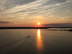
Patuxent River from the Governor Thomas Johnson Bridge
|
|

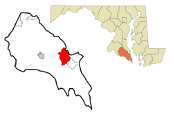
Location of California, Maryland
|
|
| Country | |
| State | |
| County | St. Mary's |
| Area | |
| • Total | 14.98 sq mi (38.80 km2) |
| • Land | 12.87 sq mi (33.32 km2) |
| • Water | 2.11 sq mi (5.48 km2) |
| Elevation | 105 ft (33 m) |
| Population
(2020)
|
|
| • Total | 12,947 |
| • Density | 1,006.30/sq mi (388.53/km2) |
| Time zone | UTC−5 (Eastern (EST)) |
| • Summer (DST) | UTC−4 (EDT) |
| ZIP code |
20619
|
| Area code(s) | 301, 240 |
| FIPS code | 24-12150 |
| GNIS feature ID | 0594621 |
California is a community in St. Mary's County, Maryland, United States. It is called a census-designated place, which means it's an area identified by the United States Census Bureau for statistics. In 2020, about 12,947 people lived there. California has been growing a lot. This is partly because more people are moving from nearby Lexington Park. Also, many jobs related to technology and defense at the Patuxent River Naval Air Station have brought more people to the area.
You can find many stores and shopping centers along Maryland Highway 235, also known as "Three Notch Road." Another important road, Maryland Route 4, crosses Highway 235 in California. This road leads to the large Governor Thomas Johnson Bridge. On the other side of the bridge is Solomons, a popular town for weekend trips. Sometimes, traffic on the bridge can get very busy during rush hour.
History of California, Maryland
The community of California was given its name before the year 1897. No one is completely sure how it got its name. However, one popular story says that a family from the state of California moved to this area. They supposedly used building materials from their home state to build their new house. They called their new home the "California Farmstead." Over time, the name stuck for the whole community.
Geography and Location
California is located in Maryland at these coordinates: 38°18′20″N 76°29′40″W / 38.305506°N 76.494517°W.
The United States Census Bureau reports that California covers a total area of about 14.8 square miles (38.3 square kilometers). Most of this area, about 12.8 square miles (33.2 square kilometers), is land. The rest, about 1.9 square miles (4.9 square kilometers), is water. This means about 12.64% of California's area is water.
People and Population
| Historical population | |||
|---|---|---|---|
| Census | Pop. | %± | |
| 1980 | 5,770 | — | |
| 1990 | 7,626 | 32.2% | |
| 2000 | 9,307 | 22.0% | |
| 2010 | 11,857 | 27.4% | |
| 2020 | 12,947 | 9.2% | |
| source: | |||
According to the census taken in 2010, there were 11,857 people living in California. These people lived in 4,327 homes. The population density was about 928 people per square mile (358 people per square kilometer). Most homes, about 71.8%, were owned by the people living in them.
The people living in California come from many different backgrounds. In 2010, about 70.7% of the people were White. About 18.3% were Black. Around 5.7% were Hispanic or Latino. Also, 4.6% were Asian, and 0.5% were Indigenous American.
Many households in California have children. About 42.7% of homes had children under 18 living there. The average household had about 2.74 people. The average family had about 3.31 people.
The median age of people in California was 32.5 years. This means half the people were younger than 32.5, and half were older. About 29.8% of the population was under 20 years old.
In 2017, California, Maryland, was noted for having many households with a lot of money to invest. In 2019, Forbes Magazine ranked California, Maryland, as one of the best small places in the country for businesses and careers. It was ranked 69th overall.
See also
 In Spanish: California (Maryland) para niños
 | Sharif Bey |
 | Hale Woodruff |
 | Richmond Barthé |
 | Purvis Young |

