
California Historical Landmarks in Stanislaus County facts for kids
This article lists important historical places and districts in Stanislaus County, California. These places are recognized as California Historical Landmarks because they played a big part in California's history. You can learn about old towns, important buildings, and places that tell stories from the past. Each landmark has a unique story, from the exciting days of the Gold Rush to other significant events that shaped the county.
Contents
Exploring Stanislaus County's Historic Places
Empire City: A Gold Rush Town
Empire City was once a busy town during the California Gold Rush. It was founded in 1850 and quickly became an important center for miners and traders. Today, you can find this historic spot at the Empire Community Park in Empire. It reminds us of the early days when people rushed to California hoping to find gold and build new lives.

Knights Ferry: A Bridge Through Time
Knights Ferry is a historic district known for its amazing covered bridge, which is the longest covered bridge west of the Mississippi River. This town was a key crossing point over the Stanislaus River during the Gold Rush. It was founded in 1849 and has many buildings that look just like they did in the 1800s. It's also listed on the National Register of Historic Places, which means it's recognized as a very important historical site in the United States.

La Grange: Another Gold Rush Gem
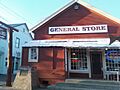
La Grange is another historic district that played a big role in the Gold Rush. It was established in 1850 and became a supply center for miners working in the nearby gold fields. The town still has some of its original charm and buildings, giving visitors a glimpse into what life was like during that exciting time.

Turlock Assembly Center: A Difficult Past
The Turlock Assembly Center was located at the Stanislaus County Fairgrounds in Turlock. During World War II, this site was used as a temporary holding facility for Japanese Americans. They were moved from their homes on the West Coast to these centers before being sent to more permanent relocation camps. It's a significant reminder of a challenging time in American history.

Willms Ranch: A Pioneer's Home
The Willms Ranch, located near Knights Ferry, is a historic property that dates back to the early days of California's settlement. It represents the agricultural history of the region and the lives of the pioneers who settled the land. The ranch shows how people lived and worked in Stanislaus County in the mid-1800s.

Images for kids
-
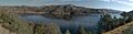
A view near Empire City, a historic Gold Rush settlement.
-
The historic covered bridge at Knights Ferry.
-
An old stage stop in La Grange, a reminder of its Gold Rush past.
-
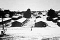
The Turlock Assembly Center in 1942.
-
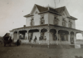
An image of the historic Willms Ranch from 1852.
