
California water resource region facts for kids
The California water resource region is a special way to divide up the land based on where water flows. Think of it like a giant map that shows all the rivers, lakes, and streams that are connected. This helps experts like the United States Geological Survey study and manage water resources.
This California region is one of 21 major water areas in the country. It covers about 168,579 square miles (436,620 km²). It includes parts of California, Nevada, and Oregon. All the water in this region either flows into the Pacific Ocean from California or into special "closed basins" within the state. Closed basins are areas where water collects but doesn't flow out to the ocean.
This large region is further divided into 10 smaller parts called subregions. Each subregion has its own unique features and water systems.

Understanding California's Water Subregions
To help manage water, each subregion has a special code called a Hydrologic Unit Code (HUC). The California region itself has a HUC of 18. Its subregions have 4-digit HUCs, from 1801 to 1810.
These subregions help scientists and water managers understand how water moves across the land. They can study things like rainfall, river flow, and water quality in each specific area. This is important for planning how we use water for homes, farms, and nature.
The 10 Water Subregions
Here are the 10 main water subregions within the California water resource region:
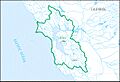
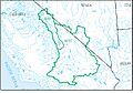
- Klamath–Northern California Coastal subregion (HUC 1801): This area includes rivers like the Smith River. It covers the coast from the Smith River Basin down to the Stemple Creek Basin. It's found in both California and Oregon.
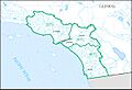
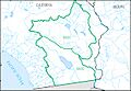
- Sacramento subregion (HUC 1802): This subregion is home to the important Sacramento River Basin. It also includes the area where water flows into Goose Lake. This part is in California and Oregon.
- Tulare–Buena Vista Lakes subregion (HUC 1803): This area covers the land where water flows into the closed basins of Tulare and Buena Vista Lakes. It is located entirely within California.
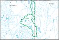
- San Joaquin subregion (HUC 1804): This subregion is centered around the San Joaquin River Basin. It is an important agricultural area in California.
- San Francisco Bay subregion (HUC 1805): This area includes the water that flows into the Pacific Ocean from the Stemple Creek Basin to the Pescadero Creek Basin. It also excludes the Sacramento and San Joaquin River Basins. This subregion is in California.
- Central California Coastal subregion (HUC 1806): This area covers the coast from the Pescadero Creek Basin down to the Rincon Creek Basin. It is located entirely within California.
- Southern California Coastal subregion (HUC 1807): This subregion includes all the water that flows into the Pacific Ocean from the Rincon Creek Basin down to the border with Baja California. It is in California.
- North Lahontan subregion (HUC 1808): This area is east of the Sierra Nevada mountains. It includes closed basins that flow into California, north of the Truckee River Basin. It covers parts of California and Nevada.
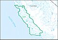
- Northern Mojave–Mono Lake subregion (HUC 1809): This subregion includes several closed desert basins in south-central California. Famous places like Mono Lake, Owens Lake, Death Valley, and the Upper Mojave Desert are in this area. It spans California and Nevada.
- Southern Mojave–Salton Sea subregion (HUC 1810): This area covers the closed desert basins in southeastern California. It includes the Lower Mojave Desert and the Salton Sea. This subregion is entirely within California.
Images for kids
-
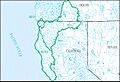
Klamath–Northern California Coastal subregion (HUC 1801)
-
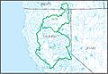
Sacramento subregion (HUC 1802)
-
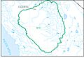
Tulare–Buena Vista Lakes subregion (HUC 1803)
-
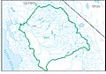
San Joaquin subregion (HUC 1804)
-
San Francisco Bay subregion (HUC 1805)
-
Central California Coastal subregion (HUC 1806)
-
Southern California Coastal subregion (HUC 1807)
-
North Lahontan subregion (HUC 1808)
-
Northern Mojave–Mono Lake subregion (HUC 1809)
-
Southern Mojave–Salton Sea subregion (HUC 1810)


