Calverton, Virginia facts for kids
Quick facts for kids
Calverton, Virginia
|
|
|---|---|

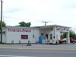
Calverton Market
|
|
| Country | United States |
| State | Virginia |
| County | Fauquier |
| Area | |
| • Total | 4.61 sq mi (11.95 km2) |
| • Land | 4.59 sq mi (11.88 km2) |
| • Water | 0.03 sq mi (0.07 km2) |
| Elevation | 259 ft (79 m) |
| Population
(2010)
|
|
| • Total | 239 |
| • Density | 52/sq mi (20.1/km2) |
| Time zone | UTC−5 (Eastern (EST)) |
| • Summer (DST) | UTC−4 (EDT) |
| ZIP code |
20138
|
| FIPS code | 51-12264 |
| GNIS feature ID | 1492694 |
Calverton is a small community in Fauquier County, Virginia, in the United States. It is known as a census-designated place (CDP). This means it is an area defined by the government for counting people. In 2010, about 239 people lived there.
Calverton is located along Virginia State Route 28. It also has a crossroad called Bristersburg Road. The community has a Southern States store, a small country store, and a post office. Its ZIP code is 20138.
Contents
What's in a Name?
Calverton might have been named after Calvert County, Maryland. A family named Bastable moved to the area from Maryland between 1850 and 1860. One family member, Gilbert Bastable, lived in Calvert County before returning to Virginia after the American Civil War.
Historic Places
The Calverton Historic District was added to the National Register of Historic Places in 2010. This list recognizes places that are important to the history of the United States.
Geography
Where is Calverton?
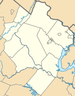
Calverton is located in the southeastern part of Fauquier County. It is situated between two other communities along Virginia Route 28. To the northeast is Catlett, and to the southwest is Midland.
The county seat, Warrenton, is about 10 miles (16 km) to the northwest. You can reach Warrenton by taking Casanova Road and Meetze Road.
Land and Water
The U.S. Census Bureau helps us understand the size of Calverton. The Calverton CDP covers a total area of about 11.95 square kilometers (4.61 square miles). Most of this area, about 11.88 square kilometers (4.59 square miles), is land.
A small part, about 0.07 square kilometers (0.03 square miles), is water. This water makes up about 0.59% of Calverton's total area.
Local Waterways
A stream called Owl Run flows through the middle of Calverton. Owl Run is a tributary of Cedar Run. A tributary is a smaller stream that flows into a larger one. Cedar Run is part of the Occoquan River watershed. A watershed is an area of land where all the water drains into a common river or lake. The Occoquan River eventually flows into the Potomac River.
Community Development
Future Plans for Calverton
The government of Fauquier County has a special plan for Calverton. They want Calverton to remain a small, rural village. This village should be surrounded by farms and open spaces. The plan aims for a good balance of homes and other buildings. It also focuses on protecting wildlife.
Challenges for Growth
The county has set careful goals for Calverton's growth. This is because there have been challenges with how the community handles its water and waste. The county wants to make sure that Calverton can grow in a way that is good for everyone. They are working to provide public sewer systems to help manage these services.
See also
 In Spanish: Calverton (Virginia) para niños
 | Victor J. Glover |
 | Yvonne Cagle |
 | Jeanette Epps |
 | Bernard A. Harris Jr. |


