
Cambria Township, Michigan facts for kids
Quick facts for kids
Cambria Township, Michigan
|
|
|---|---|
.jpg)
Township Hall and Community Center
|
|

Location within Hillsdale County
|
|

Cambria Township, Michigan
Location in Michigan

Cambria Township, Michigan
Location in the United States
|
|
| Country | United States |
| State | Michigan |
| County | Hillsdale |
| Established | 1841 |
| Area | |
| • Total | 36.14 sq mi (93.60 km2) |
| • Land | 34.81 sq mi (90.16 km2) |
| • Water | 1.33 sq mi (3.44 km2) |
| Elevation | 1,119 ft (341 m) |
| Population
(2020)
|
|
| • Total | 2,229 |
| • Density | 64.0/sq mi (24.7/km2) |
| Time zone | UTC-5 (Eastern (EST)) |
| • Summer (DST) | UTC-4 (EDT) |
| ZIP code(s) | |
| Area code(s) | 517 |
| FIPS code | 26-12700 |
| GNIS feature ID | 1626025 |
Cambria Township is a local government area in Hillsdale County, Michigan. It's like a small town or district with its own local government. In 2020, about 2,229 people lived here.
Contents
A Look Back: History of Cambria Township
Cambria Township was created in 1841. It got its name from Cambria, New York. Many of the first people who settled here came from that New York town.
Exploring Communities in Cambria Township
Cambria Township is home to a few smaller communities. These are places where people live, but they don't have their own separate city governments.
- Bankers is a community in the northern part of the township. It's right on the edge of Hillsdale Township. Horace and George Banker started this community in 1838. A railway line was built through Bankers in 1871. This made it a busy spot, especially because it had a sawmill. Bankers even had its own post office for many years, from 1872 to 1909.
- Cambria is another community. It's located in the southern part of the township. This area is also recognized as a "census-designated place." This means the U.S. Census Bureau counts it as a specific area for population statistics.
- Steamburg is a community within the township. It was named after a sawmill that used steam power, built by Chauncey Ferris. Steamburg also had its own post office from 1896 to 1902. A famous old home, the Bates homestead, was in Steamburg. It was badly damaged by a strong storm in 1965 and later taken down.
Where is Cambria Township?
Cambria Township covers an area of about 36.14 square miles (93.60 square kilometers). Most of this area, about 34.81 square miles (90.16 square kilometers), is land. The rest, about 1.33 square miles (3.44 square kilometers), is water.
Main Roads in the Township
- M-99 (also known as Hudson Road) briefly passes through the northeast corner of the township.
Who Lives in Cambria Township?
In 2000, there were 2,546 people living in Cambria Township. Most of the people were White (about 97%). A small number were African American, Native American, or Asian. Some people were also from other backgrounds.
About 32% of the homes had children under 18 living there. Most homes (61.3%) were married couples. The average age of people in the township was 38 years old.
The average income for a family in the township was around $46,650 per year. About 8.2% of all the people in the township lived below the poverty line. This included about 5% of kids under 18.
Learning in Cambria Township
Students in Cambria Township attend schools from three different public school districts:
- Most of the township is part of Hillsdale Community Schools.
- The southwest part of the township is served by Reading Community Schools.
- A very small area in the southeast is part of Camden-Frontier Schools.
Images for kids
-
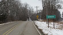
Northbound Bankers Road
-
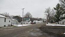
The community of Bankers
-
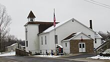
Bankers Baptist Church
-
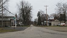
The community of Cambria

.jpg)
.jpg)
.jpg)
See also
 In Spanish: Municipio de Cambria (Míchigan) para niños
