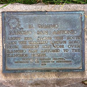
Camino of Rancho San Antonio facts for kids
Quick facts for kids Camino of Rancho San Antonio |
|
|---|---|
 |
|
| Location | SW corner of Oakland and Santa Clara Aves. Oakland, California |
| Designated | March 22, 1939 |
| Reference no. | 299 |
| Lua error in Module:Location_map at line 420: attempt to index field 'wikibase' (a nil value). | |
The Camino of Rancho San Antonio was an important old road in Alameda County, California. A camino is a Spanish word for a path or road. This historic path helped people travel long ago.
It first connected Fruitvale to Mission San José. Over time, the camino grew longer. It eventually stretched from the Temescal area of Oakland all the way to San Pablo.
The Camino's Journey Through Time
This old road was a key route for travelers. It helped people move between different settlements. The camino started in Fruitvale and went to Mission San José.
Later, it expanded north through Oakland. It passed through neighborhoods like Temescal. The road also connected towns such as San Leandro and San Lorenzo. Finally, it reached San Pablo.
Traces of the Old Road
For many years, you could still see parts of the old camino. Around 1870, some areas in Oakland showed dips in the ground. These dips were left by the wheels of wagons and carts. They showed where the road used to be.
One section of Santa Clara Avenue in Oakland still follows the camino's path. This part is near Grand Avenue and Harrison Street. It's a modern road built right on top of history.
Why the Camino is Remembered Today
The Camino of Rancho San Antonio is no longer a road people use for travel. But it is still important for its history. It is recognized as a California Historical Landmark.
It holds the number 299 on the list of California Historical Landmarks. This means it's a special place that helps us remember the past. It shows how people traveled and lived long ago in California.

