
Canal Area, San Rafael, California facts for kids
The Canal Area is made up of two neighborhoods in San Rafael, California. These areas are called "Canal Waterfront" and "Canal" by the city.
This area is located next to the San Francisco Bay on the east and the San Rafael Canal on the north. To the south and west, it's bordered by Highways 101 and I-580, and by San Quentin Ridge. The land here is used almost equally for homes and for businesses or industries.
The Canal Area offers many affordable homes in Marin County, which is known as one of the richest counties in the United States. It's also where important transportation and waste management facilities are located, serving Marin County and the North Bay. The Canal Area is home to a very diverse community, with many families from different backgrounds living there.
Contents
Homes and People
The Canal Area is home to many different kinds of families. Some residents live in houses built in the 1960s right along the Canal. There are also newer housing areas like Baypoint Lagoons (built in the late 1990s) and Spinnaker Point. These newer areas are sometimes called "East San Rafael" by real estate agents.
This area is important because it allows people who work in essential jobs, like those in local businesses, to live close to where they work. Even though many residents work in jobs that pay less, most of their apartments are not cheaper than similar ones in other parts of San Rafael.
Parks and Fun Places
Between the newer homes and the Bay, you'll find a paved path called Shoreline Park. It's a great spot for a walk or a bike ride with nice views. This path, along with a bike path owned by the Spinnaker Point Homeowner's Association, forms a square shape.
A good way to visit Shoreline Park is to start at Pickleweed Park. Then, you can walk east along the north side of the square. Pickleweed Park has a big community center, soccer fields, and a playground where you can have fun.
The western and southern parts of the Canal Area have many stores, offices, and businesses. You can find most of San Rafael's auto-body shops here. Also, Country Club Bowl, which is the only bowling alley left in Marin County, is located in this area.
Big Businesses and Facilities
Industrial Light and Magic, a company famous for creating movie special effects, used to have a large office space here. In 1997, they built a "main stage" for making movie effects, which is still used today. However, most of their office space moved to San Francisco in 2005.
Transportation and Waste Facilities
The southeastern part of the Canal Area, between I-580 and San Quentin Ridge, is home to several important facilities. These places help with transportation and waste processing for much of Marin County. They include:
- Central Marin Sanitation Agency
- Golden Gate Transit bus yard and maintenance facility
- Marin Recycling Center
- Marin Resource Recovery Center
- Marin Sanitary Service and its transfer station
- United Parcel Service
Old Landfills
The "East San Rafael" area, which is the eastern part of the Canal Area between the Bay and San Quentin Ridge, used to be where most of the garbage from central Marin County was taken. These old garbage sites are now closed.
Images for kids
-
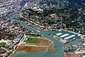
Aerial view of the San Rafael Canal, looking west. The northern tip of the Canal Area is on the left, with Pickleweed Park in the central foreground.

