Canary Islands Seamount Province facts for kids
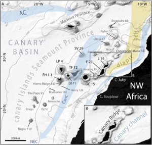
The Canary Islands Seamount Province (CISP) is a special area in the Atlantic Ocean. It's located between 23 and 33 degrees north latitude. Think of it as a huge underwater region that includes the seven main Canary Islands, the two small Savage Islands, and 16 seamounts.
A seamount is basically an underwater mountain. This whole province covers a massive area of about 540,000 square kilometers. That's a lot of ocean! It runs alongside the northwest coast of Africa. All the parts of this province, from the islands to the seamounts, are connected by similar types of rocks and chemicals found in them.
Underwater Mountain Chains
Scientists have found three main lines or chains of these underwater mountains and islands within the CISP. These lines show how the land formed over a very long time.
- One chain stretches from the Tropic Seamount in the southwest all the way to the westernmost part of the Canary Islands.
- Another chain goes from the Canary Islands of La Palma and El Hierro in the northwest to the island of Fuerteventura in the southeast. This chain is about 400 kilometers long.
- The third chain is called the Canary Ridge. It starts near Fuerteventura and goes towards the Concepción Bank. From there, it turns and heads north towards the Essaouira Seamount.
Important Seamounts
Many interesting seamounts are part of the Canary Islands Seamount Province. Here are a few of them:
- Echo Seamount
- Tropic Seamount
- Concepción Bank
- Tagoro
- The Paps
See also
 In Spanish: Provincia de Montes Submarinos de las Islas Canarias para niños
 | Chris Smalls |
 | Fred Hampton |
 | Ralph Abernathy |


