Tagoro facts for kids
Quick facts for kids Tagoro |
|
|---|---|
|
Lua error in Module:Location_map at line 416: Malformed coordinates value.
|
|
 |
|
| Location | |
| Location | North Atlantic |
| Group | Canary Islands Seamount Province |
| Coordinates | Lua error in Module:Coordinates at line 614: attempt to index field 'wikibase' (a nil value). |
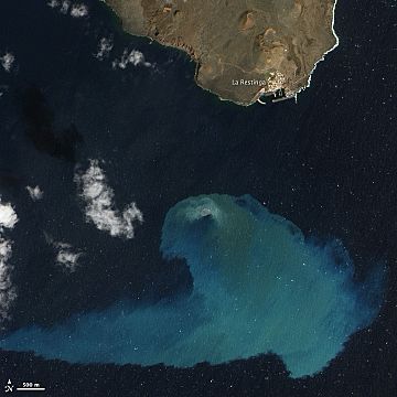
Tagoro is a special kind of volcano that is completely underwater. It is found off the southern coast of El Hierro, one of the Canary Islands, in the Atlantic Ocean. Tagoro is part of a group of underwater mountains called the Canary Islands Seamount Province.
How Tagoro Was Born
Tagoro was formed during an eruption that began on October 10, 2011. This underwater eruption happened about 1.8 kilometers (just over 1 mile) south of El Hierro island, near a town called La Restinga.
When the eruption started, the top of the volcano was 355 meters (about 1,165 feet) below the surface of the sea. By February 2012, it had grown much taller, reaching a height of about 88 meters (about 289 feet) below sea level. During this time, Tagoro released a lot of hot magma (melted rock), gases, and heat. This changed the ocean environment around it quite a bit.
Life After the Eruption
After the main eruption stopped, Tagoro entered a new stage in March 2012. This is called a hydrothermal phase. During this phase, the volcano continued to release hot water and gases from its vents.
Scientists have watched Tagoro closely since its eruption. They found that the volcano has made the nearby ocean waters richer in nutrients. It releases many dissolved minerals that act like fertilizer for sea life. This helps small ocean plants and animals to grow.
For a few years, people just called it the "submarine volcano of El Hierro island." But in 2016, the Spanish Instituto Hidrográfico de la Marina (a Spanish ocean mapping group) officially named it Tagoro. This name was suggested by another group, the Instituto Español de Oceanografía. Tagoro is a word from the Berber languages spoken by the native people of the Canary Islands. It means something like 'a circular area made of stones' or 'a meeting place'.
See also
 In Spanish: Tagoro (volcán) para niños
 | Delilah Pierce |
 | Gordon Parks |
 | Augusta Savage |
 | Charles Ethan Porter |

