Canaseraga, New York facts for kids
Quick facts for kids
Canaseraga, New York
|
|
|---|---|
|
Village
|
|

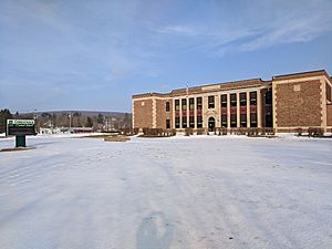
Canaseraga Central School
|
|
| Country | United States |
| State | New York |
| County | Allegany |
| Town | Burns |
| Area | |
| • Total | 1.06 sq mi (2.75 km2) |
| • Land | 1.06 sq mi (2.75 km2) |
| • Water | 0.00 sq mi (0.00 km2) |
| Elevation | 1,250 ft (381 m) |
| Population
(2020)
|
|
| • Total | 460 |
| • Density | 433.15/sq mi (167.19/km2) |
| Time zone | UTC-5 (Eastern (EST)) |
| • Summer (DST) | UTC-4 (EDT) |
| ZIP code |
14822
|
| Area code(s) | 607 |
| FIPS code | 36-12177 |
| GNIS feature ID | 0945753 |
Canaseraga is a small village located in Allegany County, New York, United States. In 2020, about 460 people lived there.
The village's name comes from a nearby creek. It is believed to be a Seneca term. It might mean "lying among milkweeds" or "slippery elms." Canaseraga is in the northern part of the town of Burns. It sits where New York State Route 70 and County Road 13 meet.
Contents
Village History
Canaseraga was one of the first places settled in the town of Burns. However, it was less important than the community of Burns until around 1840. The village of Canaseraga officially became a village in 1892. It was first known as "Whitney Valley."
Changes Over Time
A big fire caused the village to become much smaller than it used to be. Today, many people travel to nearby towns for shopping or to see movies. Canaseraga has fewer options for these activities.
Local School and Activities
The village has one school that teaches students from pre-kindergarten all the way to 12th grade. The school offers several sports. These include soccer, basketball, skiing, track, baseball, and softball. The track team has joined with Arkport.
Canaseraga also hosts a fun Fall Harvest Festival. This event offers many activities for families to enjoy.
Historic Places
The Canaseraga Four Corners Historic District is an important area in the village. It was added to the National Register of Historic Places in 2002. This means it is recognized for its historical importance.
Village Geography
Canaseraga is located at 42°27′45″N 77°46′36″W / 42.46250°N 77.77667°W. This is its exact spot on a map.
Area and Land
According to the United States Census Bureau, the village covers an area of about 2.75 square kilometers. All of this area is land. There is no water within the village limits.
Nearby Waterways
The village is right next to Canaseraga Creek. This creek flows into the Genesee River. Two other creeks, Bennett Creek and Slader Creek, join Canaseraga Creek west of the village. Canaseraga is also just south of Livingston County.
Population Information
| Historical population | |||
|---|---|---|---|
| Census | Pop. | %± | |
| 1880 | 791 | — | |
| 1890 | 659 | −16.7% | |
| 1900 | 685 | 3.9% | |
| 1910 | 754 | 10.1% | |
| 1920 | 651 | −13.7% | |
| 1930 | 620 | −4.8% | |
| 1940 | 698 | 12.6% | |
| 1950 | 693 | −0.7% | |
| 1960 | 730 | 5.3% | |
| 1970 | 750 | 2.7% | |
| 1980 | 700 | −6.7% | |
| 1990 | 684 | −2.3% | |
| 2000 | 594 | −13.2% | |
| 2010 | 550 | −7.4% | |
| 2020 | 460 | −16.4% | |
| U.S. Decennial Census | |||
In 2000, the village had 594 people living there. There were 220 households and 166 families. The population density was about 465 people per square mile.
Who Lives in Canaseraga?
About 36.4% of households had children under 18. Most households, 57.3%, were married couples. About 20.9% of households were single people living alone. The average household had 2.70 people.
Age Groups
The population was spread out by age. About 28.8% of people were under 18 years old. About 12.3% were 65 years or older. The average age in the village was 36 years old. For every 100 females, there were about 104.8 males.
Income and Economy
In 2000, the average income for a household in Canaseraga was $35,469 per year. For families, the average income was $39,000. About 12.8% of the total population lived below the poverty line. This included 23.4% of those under 18.
See also
 In Spanish: Canaseraga para niños
 | Leon Lynch |
 | Milton P. Webster |
 | Ferdinand Smith |


