Canchal de la Ceja facts for kids
Quick facts for kids Canchal de la Ceja |
|
|---|---|

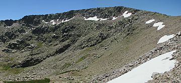
North face of the mountain
|
|
| Highest point | |
| Elevation | 2,428 m (7,966 ft) |
| Prominence | 1,153 m (3,783 ft) |
| Naming | |
| English translation | Eyebrow scree |
| Language of name | Spanish |
| Geography | |
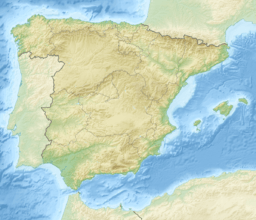
| Location | Ávila (Castile and León) Salamanca (Castile and León) |
| Parent range | Sierra de Béjar (Sistema Central) |
| Climbing | |
| Easiest route | hike |
The Canchal de la Ceja is a tall mountain in Spain, standing at 2,428 metres (about 7,966 feet) high. It's a popular spot for hiking and offers amazing views.
Contents
What Does "Canchal de la Ceja" Mean?
The name Canchal means scree, which is a slope covered in broken rocks. The second part, Ceja, means eyebrow. This name comes from the special shape of the snowfield found below the mountain's top on its northern side. It looks a bit like an eyebrow!
Where is Canchal de la Ceja Located?
This mountain sits right on the border between two Spanish provinces: Ávila and Salamanca. Both of these provinces are part of the Castile and León region in Spain.
Canchal de la Ceja is the highest point in the Sierra de Béjar mountain range. It's also the tallest mountain in the entire Province of Salamanca. Around the mountain, you'll find some of the biggest lakes in the Sierra de Gredos area.
How Can You Reach the Summit?
The easiest way to get to the top of Canchal de la Ceja is by hiking. The shortest path starts from a place called Plataforma del Travieso. This spot is about 1,850 metres high and around 10 kilometres from the town of Candelario.
From there, it usually takes just a couple of hours to hike to the very top. If you're into more challenging adventures, the northern side of the mountain also has some climbing routes for experienced climbers.
See also
 In Spanish: Canchal de la Ceja para niños
- Sistema Central
 | Kyle Baker |
 | Joseph Yoakum |
 | Laura Wheeler Waring |
 | Henry Ossawa Tanner |


