
Cann Quarry Canal facts for kids
Quick facts for kids Cann Quarry Canal |
|
|---|---|

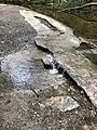
Much of the canal is still visible
|
|
| Specifications | |
| Status | abandoned |
| History | |
| Date of act | Privately built |
| Date of first use | 1829 |
| Date closed | 1839 |
| Geography | |
| Start point | Cann Quarry |
| End point | Marsh Mills |
The Cann Quarry Canal was a waterway in Devon, England. It was a short canal, less than 2 miles (3.2 km) long. The canal ran from Cann Quarry to the River Plym at Marsh Mills.
It opened in 1829. A short tramway connected it to the Plymouth and Dartmoor Railway at Crabtree Junction. The canal was replaced by a tramway within ten years. However, it continued to be used to supply water to Marsh Mills corn mill. Most of the old canal route is still visible today.
Contents
History of the Cann Quarry Canal
In 1778, the Cann Slate Quarry was owned by John Parker. He wanted to make it easier to transport slate from his quarry. So, he asked an engineer named John Smeaton to survey a route for a canal. This canal would run from the quarry to a bridge at Marsh Mills. The River Plym was already navigable by barges from this bridge down to Plymouth.
Smeaton completed his survey. He found that the canal would be about 2.25 miles (3.6 km) long. It would also need several locks to handle a 30-foot (9.1 m) drop in height. Smeaton thought the canal would not be very profitable. This was because the only goods it would carry were from the quarry. He suggested building a tramway instead. A tramway would cost about half as much as a canal. Parker did not build either option at that time.
Plans for a Tramway Connection
In 1819, a special law called an Act of Parliament was passed. This law allowed a horse tramway to be built between Princetown and Plymouth. In 1821, the people in charge of the Plymouth and Dartmoor horse tramway asked for another Act. They wanted to change part of their planned route.
To get permission for the new route, they made a deal with John Parker's son. He was also named John Parker and had become the Earl of Morley in 1815. They agreed to build a branch line to the quarry. This branch might have included a sloped section called an inclined plane.
The tramway company faced money problems. Because of this, the branch line to the quarry was not built. Even though Earl Morley was on the tramway's management team, he took legal action. He sued the three directors who had suggested building the branch. They then suggested that he should build the branch himself. In return, any goods moved from his branch to their tramway would have lower fees.
Building the Canal and Tramway
Earl Morley decided to build a small boat canal from the quarry to Marsh Mills. This canal was about 6 feet (1.8 m) wide. It ended just above the bridge at Marsh Mills. He then wrote to the tramway company. He said he was not sure whether to finish the canal by digging a tunnel under the main road to connect it to the river. Or, he could link it to their tramway at Crabtree with a private branch line.
This letter led to an agreement about fees. As a result, a private tramway was built to connect the canal to the main line. The canal itself was a little less than 2 miles (3.2 km) long. The new tramway was about 0.5 miles (0.8 km) long. It crossed the river on a cast iron bridge with two arches.
Canal Opening and Later Use
The Cann Quarry Canal officially opened on November 20, 1829. Sometime between 1834 and 1839, Earl Morley's tramway was extended. It went further up the valley to Cann Quarry. Near the quarry, the tramway was built on the canal bank. But further down, it was built a bit to the west.
Once this extended tramway opened, the canal was no longer used for boats. Instead, it became a mill leat. This means it was used to carry water to power the corn mill at Marsh Mills. A branch of the tramway was built from Plym Bridge to the quarries at Lee Moor. This branch had an unusual track width of 4 feet 6 inches (1,372 mm). The entire railway system became known as the Lee Moor Tramway.
The South Devon and Tavistock Railway built its own branch line up the Plym Valley. This line was finished in 1854. For most of its route between Marsh Mills and the quarry, it ran between Earl Morley's tramway and the canal. The new railway cut across the quarry, which then closed the next year. Marsh Mills corn mill kept working until 1927, when its owners went out of business.
Route of the Canal Today
The area around Crabtree Junction has changed a lot. This is where Earl Morley's Tramway met the Plymouth and Dartmouth Railway. Today, it's covered by a motel and a road interchange. However, the two-arched cast iron bridge over the River Plym is still there.
The old tramway route towards the quarry is now a cycleway and a long-distance walking path. It is known as the West Devon Way. Most of the canal itself is still visible. It often fills with water after it rains. However, the very last part of the canal at Marsh Mills can no longer be seen.
The branch line of the South Devon and Tavistock Railway was abandoned. But the lower part of it is now used by the Plym Valley Railway. The current Marsh Mills Station is a bit further north than the original one. This is because a railway line that serves a china clay works still runs through the old station site. The Plym Valley Railway is being extended to Plym Bridge. This is where the Lee Moor incline used to branch off. The railway crosses the canal's route in two places along this section. Both of these bridges have been rebuilt as part of the railway's restoration. Beyond Plym Bridge, the cycleway leaves Earl Morley's tramway. It then follows the South Devon and Tavistock Railway instead. This allows it to cross the River Plym just past Cann Quarry. From there, it continues on to Yelverton.
Points of Interest
| Point | Coordinates (Links to map resources) |
OS Grid Ref | Notes |
|---|---|---|---|
| Cann Quarry wharf | 50°25′00″N 4°04′50″W / 50.4167°N 4.0806°W | SX522594 | Canal and tramway |
| Plym Bridge | 50°24′33″N 4°04′42″W / 50.4091°N 4.0784°W | SX524586 | Tramway jn with Lee Moor branch |
| Rebuilt bridge 3 | 50°24′09″N 4°05′10″W / 50.4024°N 4.0862°W | SX518579 | Plym Valley Railway |
| Rebuilt bridge 2 | 50°24′03″N 4°05′10″W / 50.4007°N 4.0860°W | SX518577 | Plym Valley Railway |
| Marsh Mills corn mill | 50°23′33″N 4°04′53″W / 50.3924°N 4.0813°W | SX521567 | southern terminus |
| Cast iron tramway bridge | 50°23′34″N 4°05′01″W / 50.3927°N 4.0835°W | SX519568 | built 1823 |
| Crabtree Junction | 50°23′25″N 4°05′20″W / 50.3903°N 4.0888°W | SX516565 | End of Earl Morley's Tramway |
Images for kids
-
The towpath of the disused Cann Quarry Canal, Plymbridge, after rain

