Cantaracillo facts for kids
Quick facts for kids
Cantaracillo
|
|
|---|---|
 |
|

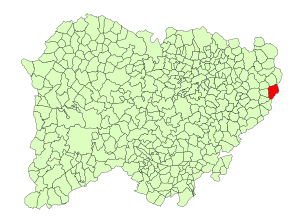
Location in Salamanca
|
|
| Country | Spain |
| Autonomous community | Castile and León |
| Province | Salamanca |
| Comarca | Tierra de Peñaranda |
| Area | |
| • Total | 37 km2 (14 sq mi) |
| Elevation | 913 m (2,995 ft) |
| Population
(2018)
|
|
| • Total | 180 |
| • Density | 4.86/km2 (12.6/sq mi) |
| Time zone | UTC+1 (CET) |
| • Summer (DST) | UTC+2 (CEST) |
| Postal code |
37319
|
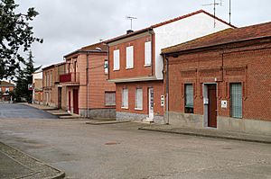
Cantaracillo is a small village and a municipality (which is like a local government area) in western Spain. It is part of the Salamanca province. This area belongs to the larger region called Castile and Leon.
Contents
About Cantaracillo
Cantaracillo is a quiet place located about 42 kilometers (that's about 26 miles) away from the main city of Salamanca. It sits quite high up, at 913 meters (or 2,995 feet) above sea level. This means it's located in an elevated area.
Where is Cantaracillo?
Cantaracillo is found in the western part of Spain. It's specifically in the province of Salamanca. This province is part of the autonomous community of Castile and León. Think of an autonomous community like a large state or region within a country.
How Big is Cantaracillo?
The municipality of Cantaracillo covers an area of 37 square kilometers (about 14 square miles). In 2016, around 204 people lived there. By 2018, the population was about 180 people. This makes it a small community.
What's the Postal Code?
Every place has a special code for mail delivery. For Cantaracillo, the postal code is 37319.
See also
 In Spanish: Cantaracillo para niños
 | Audre Lorde |
 | John Berry Meachum |
 | Ferdinand Lee Barnett |


