Cantel, Guatemala facts for kids
Quick facts for kids
Cantel
|
|
|---|---|
|
Municipality and town
|
|

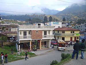
Cantel from the Quetzaltenango - Retalhueu highway
|
|
| Country | |
| Department | |
| Area | |
| • Total | 20.3 sq mi (52.6 km2) |
| Population
(2018 census)
|
|
| • Total | 42,142 |
| • Density | 2,075.0/sq mi (801.2/km2) |
| Time zone | UTC+6 (Central Time) |
| Climate | Cwb |
Cantel is a town and a municipality located in the Quetzaltenango Department in Guatemala. It's about 7 miles (11 kilometers) east of the big city of Quetzaltenango. Cantel covers an area of 52.6 square kilometers. In 2023, the town of Cantel had a population of around 47,941 people. It sits high up at an altitude of 2,370 meters (about 7,775 feet) above sea level. This makes it a cool place to live!
Contents
Exploring Cantel's Location
Cantel is part of the Quetzaltenango Department. This department is one of the 22 main areas, like states or provinces, that make up the country of Guatemala. Being 7 miles east of Quetzaltenango city means it's close enough to a larger urban center for services, but still has its own unique feel.
High Altitude Living
The town of Cantel is located at 2,370 meters (7,775 feet) above sea level. This is quite high! To give you an idea, that's higher than many mountains in other parts of the world. Living at such an altitude means the weather is often cooler than in lower areas. It also affects the types of plants and animals that can thrive there.
Cantel's Size and People
Cantel is a medium-sized municipality. Its total area is 52.6 square kilometers. This is roughly the size of a small city. The population of 47,941 people (as of 2023) means it's a busy community with many families and activities.
Ancient History in Cantel
Cantel is home to some really old places! It includes two small Maya archaeological sites. These are called Chojolom and Cerro Quiac.
What are Maya Archaeological Sites?
Maya archaeological sites are places where the ancient Maya people used to live thousands of years ago. These sites often have old buildings, temples, and other structures that tell us about their amazing civilization. Finding these sites in Cantel means that people have lived in this area for a very long time.
Chojolom and Cerro Quiac
Chojolom and Cerro Quiac are important because they show us traces of the Maya civilization right in Cantel. Archaeologists study these sites to learn about how the Maya lived, what they ate, what their beliefs were, and how their societies were organized. These sites are like giant puzzles that help us understand history!
See also
 In Spanish: Cantel para niños


