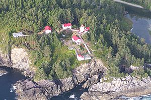
Cape Beale Light facts for kids
 |
|
| Cape Beale Lighthouse | |
|
|
|
| Location | Cape Beale Vancouver Island British Columbia Canada |
|---|---|
| Coordinates | 48°47′11″N 125°12′56″W / 48.78639°N 125.21556°W |
| Year first constructed | 1874 (first) |
| Year first lit | 1958 (current) |
| Construction | steel skeletal tower |
| Tower shape | square pyramidal tower with balcony and lantern, central cylinder, slatted daymarks on three sides |
| Markings / pattern | red tower and lantern |
| Height | 10 metres (33 ft) |
| Focal height | 48 metres (157 ft) |
| Characteristic | Fl WR 5s. |
| Admiralty number | G5256 |
| CHS number | CCG 0176 |
| NGA number | 13836 |
| ARLHS number | CAN-091 |
The Cape Beale Lightstation is an important lighthouse located on Vancouver Island in British Columbia, Canada. It is still active today and helps guide ships safely.
Contents
History of Cape Beale Lighthouse
The first lighthouse at Cape Beale was built in 1874. It was placed high up, about 51 meters (167 feet) above the ocean. This height helps its light shine far across the water.
Building the Lighthouse
The lighthouse you see today was built in 1958. It stands 10 meters (33 feet) tall. This lighthouse helps mark the entrance to Barkley Sound, a large bay on Vancouver Island.
How Cape Beale Got Its Name
The area known as Cape Beale was named by Charles William Barkley. He was the captain of a ship called the Imperial Eagle. Captain Barkley named the cape after his ship's purser, John Beale.
Lighthouse and the West Coast Trail
The Cape Beale Lighthouse is very close to the famous West Coast Trail. This trail was originally a path for shipwreck survivors. They would use it to find their way to the nearby community of Bamfield. The lighthouse would have been a welcome sight for anyone lost at sea.
Studying the Ocean
For many years, from 1971 to 1998, the Cape Beale Lightstation helped scientists. It was part of the British Columbia Shore Station Oceanographic Program. Workers at the lighthouse collected important information every day. They measured the ocean's temperature and how salty the water was. This data helped the Department of Fisheries and Oceans understand the ocean better.
 | Precious Adams |
 | Lauren Anderson |
 | Janet Collins |


