Cape Creek facts for kids
Quick facts for kids Cape Creek |
|
|---|---|

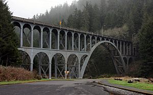
Cape Creek passes under Cape Creek Bridge, which carries U.S. Route 101.
|
|
|
Location of the mouth of Cape Creek in Oregon
|
|
| Country | United States |
| State | Oregon |
| County | Lane |
| Physical characteristics | |
| Main source | near Herman Peak Central Oregon Coast Range, Siuslaw National Forest 44°07′47″N 124°00′19″W / 44.12972°N 124.00528°W |
| River mouth | Pacific Ocean Heceta Head 44°08′03″N 124°07′25″W / 44.13417°N 124.12361°W |
Cape Creek is a stream that flows into the Pacific Ocean. It is located along the coast of Lane County in the U.S. state of Oregon. The creek starts near Herman Peak in the Central Oregon Coast Range mountains. It then flows west through the Siuslaw National Forest until it reaches the ocean at Heceta Head.
Contents
Discover Cape Creek: Oregon's Coastal Stream
Cape Creek is a beautiful waterway on the Oregon coast. It begins high up in the mountains near Herman Peak. From there, it makes its way through a large forest. The creek's journey ends when it empties into the vast Pacific Ocean.
Where Does Cape Creek Flow?
As Cape Creek flows towards the ocean, it picks up water from smaller streams. These include North Fork Cape Creek and Wapiti Creek. The creek's path takes it through a special area. This area used to be called Devil's Elbow State Park. Now, it is part of the Heceta Head Lighthouse State Scenic Viewpoint.
Exploring Heceta Head Lighthouse State Scenic Viewpoint
Near where Cape Creek meets the ocean, you'll find the Heceta Head Lighthouse State Scenic Viewpoint. This is a great place for a day trip. It has picnic tables where you can enjoy a meal. These tables are located above a small cove. This cove is where Cape Creek finally flows into the ocean.
Fun Activities at the Viewpoint
The Heceta Head Lighthouse State Scenic Viewpoint offers many fun things to do. You can take tours of the historic lighthouse. It's a great way to learn about its history. You can also go fishing in the area. Many people enjoy hiking on the trails. It's also a wonderful spot for watching local wildlife.
The Famous Cape Creek Bridge
Right before Cape Creek reaches the ocean, it flows under a very important bridge. This bridge is called the Cape Creek Bridge. It carries U.S. Route 101, a major highway along the coast. The bridge is a famous landmark in the area. It helps people travel along the beautiful Oregon coastline.
 | John T. Biggers |
 | Thomas Blackshear |
 | Mark Bradford |
 | Beverly Buchanan |


