Cape Melville facts for kids
Quick facts for kids Cape Melville |
|
|---|---|

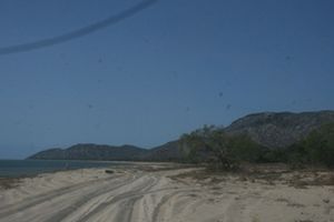
Beach at Cape Melville
|
|
| Location | Cape York Peninsula, Australia |
| Coordinates | 14°10′12″S 144°31′24″E / 14.17000°S 144.52333°E |
| Offshore water bodies | Coral Sea |
| Geology | Cape |
Cape Melville is a special piece of land that sticks out into the ocean. You can find it on the eastern coast of the Cape York Peninsula in Australia. It's located near Princess Charlotte Bay and is part of the amazing Cape Melville National Park.
A long time ago, in 1815, a man named Lieutenant Charles Jeffreys first called it 'Stoney Cape'. But he later changed the name to Cape Melville. Nearby, you'll find islands like Pipon Island, Hales Island, and King Island. These islands are part of the incredible Great Barrier Reef Marine Park.
The highest point on Cape Melville is a peak called Abbey Peak. It was named in 1901. This cape is made of huge granite rocks that formed about 250 million years ago!
A Hidden World of Nature
Cape Melville is often called a 'lost world' because of its unique nature. For millions of years, many animal species have lived in an isolated part of the rainforest here. A large area of granite boulders has protected this rainforest. These boulders have stopped bushfires from reaching the area and helped keep the ground moist.
In March 2013, a group of scientists and filmmakers visited this misty rainforest. It's located on the Melville Range, a small mountain range within Cape Melville. Not many people have explored this special place.
Unique Animals and Plants
The plants and animals found near Cape Melville are very diverse. Many of them are endemic, which means they are found nowhere else in the world!
Some of these unique species include:
- The Foxtail Palm, a beautiful tree.
- The Cape Melville leaf-tailed gecko, a lizard that blends in perfectly with its surroundings.
- The Cape Melville shade skink, another type of lizard.
- The Blotched boulder-frog, a frog that lives among the rocks.
- The Cape Melville Tree Frog, a frog that lives in the trees.
See Also
- Protected areas in Queensland
- Cape Melville affair
 | Jessica Watkins |
 | Robert Henry Lawrence Jr. |
 | Mae Jemison |
 | Sian Proctor |
 | Guion Bluford |


