Caribou Lake (Chaudières-Appalaches) facts for kids
Quick facts for kids Caribou Lake |
|
|---|---|

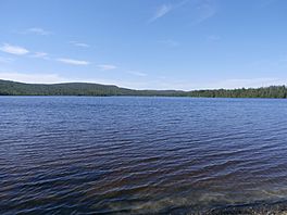
Caribou Lake seen from the 12e rang road.
|
|
| Coordinates | 46°00′55″N 71°19′55″W / 46.01533°N 71.33184°W |
| Primary inflows | Ashberham River |
| Primary outflows | Ashberham River |
| Basin countries | Canada, Quebec |
| Max. length | 2.4 kilometres (1.5 mi) |
| Max. width | 0.8 kilometres (0.50 mi) |
| Average depth | 4.88 metres (16.0 ft) |
| Surface elevation | 335 metres (1,099 ft) |
Lac Caribou is a beautiful lake found in Quebec, Canada. It's located in a place called Saint-Joseph-de-Coleraine. This area is part of the Les Appalaches Regional County Municipality and the Chaudière-Appalaches region.
The Ashberham River flows right through Lac Caribou. This river starts in the Bécancour Hills. After leaving Lac Caribou, the water travels through Petit lac Saint-François. Eventually, it joins Grand lac Saint François, which is where the Saint-François River begins. The Saint-François River then flows into the mighty St. Lawrence River.
About Lac Caribou
Lac Caribou covers an area of about 368 acres. That's roughly the size of 277 football fields! The lake sits at an elevation of 335 meters above sea level. Its deepest point is 4.88 meters.
You can easily get to the lake by using Route 112. It's a great spot for enjoying nature.
 | William Lucy |
 | Charles Hayes |
 | Cleveland Robinson |


