Carlisle Canal facts for kids
The Carlisle Canal was a waterway that opened in 1823. Its main purpose was to connect the city of Carlisle to the Solway Firth. This link made it easier to move goods like coal and timber to and from the city. However, the canal didn't last very long. It was replaced by a railway line in 1854, which actually used most of the old canal bed for its route.
Contents
History of the Canal Idea
The River Eden flows through Carlisle and into the Solway Firth. Long ago, before 1720, boats brought coal from mines near Maryport to places along the river. But in 1720, new taxes were put on goods moved by sea. This made it cheaper to transport coal by land instead.
Three traders from Carlisle wanted to bring back the cheaper sea trade. They got a special law, called an Act of Parliament, in 1721. This law allowed them to build docks and warehouses and to clear the river. They could charge fees for goods for 31 years. However, they couldn't build new waterways or locks to make the river better for boats.
Later, people started thinking about bigger canal projects. There were ideas for a canal that would cross England from coast to coast, possibly ending at Carlisle or Maryport. The traders in Carlisle mostly wanted better ways to get goods from places like Liverpool, Ireland, and Scotland. By 1795, ships were regularly bringing goods to Sandsfield, about 5.6 kilometres (3.5 miles) from Carlisle. From there, goods were moved by road to the city.
Planning the Canal
The idea of building a canal for Carlisle gained a lot of support in 1807. People wanted a cheaper and more reliable way to get coal. A group was formed to push the plan forward. They asked an engineer named William Chapman for advice. He suggested a route from Carlisle to Maryport, which he had thought of before. This canal would cost a lot, between £90,000 and £100,000. He also suggested a cheaper option to a place called Bowness-on-Solway on the Solway Firth.
Chapman offered different sizes for the canal. A smaller canal for 45-ton boats would cost £40,000. A larger one for 90-ton boats, which could travel across the Irish Sea, would cost £55,000 to £60,000. This larger canal could also be part of a coast-to-coast route.
The committee then asked another famous engineer, Thomas Telford, for his opinion in 1808. He suggested a "Cumberland Canal" that would let large ships reach Carlisle. This canal would also be part of a bigger plan to connect Carlisle to other parts of the country. Telford suggested very large locks, 6.1 metres (20 feet) wide and 2.4 metres (8 feet) deep. His plan would cost about £109,393. He also suggested a way to supply water by extending the canal to Wigton, but this would cost more. Chapman thought a steam pump would be a better way to get water. He also suggested slightly smaller locks, 19.8 metres (65 feet) long and 4.9 metres (16 feet) wide. This would allow boats called Mersey flats to reach Carlisle without having to transfer their goods to smaller boats. However, no work started at that time.
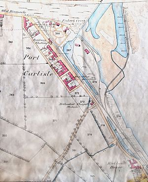
Eight and a half years later, in 1817, the idea was brought up again. Chapman was asked to survey a canal for vessels of at least 70 tons. He had to make sure it could be part of the coast-to-coast link. His plan started at Fisher's Cross, which later became known as Port Carlisle. The canal would have locks 22.6 by 5.2 metres (74 by 17 feet). The canal channel would be 15.2 metres (50 feet) wide and 2.4 metres (8 feet) deep. This plan would cost £75,392. The plan was accepted, money was raised, and a law was passed in 1819. This law allowed the Carlisle Canal to raise £80,000, and an extra £40,000 if needed.
Building the Canal
The committee hired Chapman as a consulting engineer. The actual building work started in early 1820. The canal was 18.1 kilometres (11.25 miles) long, 16.5 metres (54 feet) wide at the surface, and 2.4 metres (8 feet) deep.
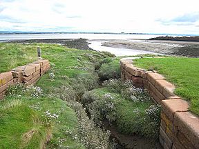
At Fisher's Cross (Port Carlisle), a large basin was built. This basin was 76.2 by 24.4 metres (250 by 80 feet). It connected to the Solway Firth through a special sea lock with a long wooden pier. Seven more locks raised the canal's level by 14 metres (46 feet) as it went towards Carlisle. At Carlisle, there was another basin, 137.2 by 30.5 metres (450 by 100 feet), with docks and a warehouse.
The locks were 23.8 metres (78 feet) long and 5.6 metres (18.5 feet) wide. Water for the canal came from a reservoir near Grinsdale. The sea lock was built so its top was at the same level as high tides. There was also a second lock nearby to keep the canal's water level steady. The canal ran level for about 9.7 kilometres (6 miles) after the first two locks. Then, the remaining six locks were grouped together over 2 kilometres (1.25 miles). After these locks, the canal ran level again all the way to Carlisle. There were no fixed bridges on the canal, so coastal ships could use it. Where roads crossed, there were special two-part drawbridges that could be opened.
The committee managed to raise £70,600 from local people. They also borrowed about £10,000 to finish the project. The total cost was just over the estimated £80,000.
How the Canal Worked
The committee worked hard to encourage trade on the canal. They even built a timber yard in Carlisle. Soon after the canal opened, the government changed the rules on coastal taxes. They removed taxes on coal, stone, and slate carried between Whitehaven and Carlisle. This was good news for the canal.
In 1825, a company called the Carlisle & Liverpool Steam Navigation Company wanted to start a passenger service from Liverpool. They asked for a special docking spot for their ship. The canal committee paid for a new spot and bought a second-hand boat called Bailie Nicol Jarvie. This boat would carry passengers from Port Carlisle to Carlisle. The passenger service began on 1 July 1826. The steamer service to Liverpool started around the same time. The steamer also carried goods, which were then moved along the canal by smaller boats. A hotel, the Solway Hotel, opened in Port Carlisle soon after.
Competition and Changes
By 1824, people in Newcastle were thinking about building a canal or a railway to Carlisle. William Chapman, the engineer, said the route was good for a railway too. He estimated a railway would be much cheaper than a canal. A railway company was formed, and they got permission to build a railway in 1829. This railway would end at the canal basin in Carlisle.
The railway opened in stages from 1836 to 1839. This new railway traffic actually helped the canal at first. The canal's income from tolls grew from £2,905 in 1835 to £6,605 by 1840. The money from the passenger boat service also increased. The canal company even started paying dividends (a share of profits) to its shareholders.
To improve the canal, the company took over the job of placing buoys (floating markers) in the Solway Firth to guide ships. They also built a new docking spot at Port Carlisle for a new service to Annan and Liverpool. In 1834, a faster passenger boat called the Arrow was bought. The company even bought an ice-breaker so the passenger service could run all year round. They also started a bus service between the Carlisle basin and the town centre.
To ensure enough water for the canal, new pumps and a steam engine were installed in 1838. These helped fill the reservoir when river levels were low. The company also worked on improving the docks at Port Carlisle and installing more buoys in the Solway Firth. A lighthouse was built at Lees Scar near Silloth in 1840.
The Rise of Railways
When the railway reached the Carlisle basin, traffic on the canal increased. This included coal from nearby mines. The canal company even used barges towed by a tug to carry coal on the Solway Firth. They also got a second passenger boat in 1838. To encourage more traffic, tolls on both the canal and railway were lowered. The increased work meant that bridge and lock keepers were paid extra.
However, this good time didn't last. The canal soon faced strong competition from new railways. The Lancaster and Carlisle Railway was approved in 1844, directly threatening the canal's steamer service. Other railways like the Maryport and Carlisle Railway and the Caledonian Railway also opened, connecting Carlisle to more places.
By 1846, the canal company seriously considered turning the canal into a railway. In 1850, cheaper railway fares to Liverpool, combined with a shorter sea journey from Whitehaven, affected the canal's passenger traffic. In March 1852, the company decided that converting the canal into a railway was the best option. They raised money and got permission from Parliament.
Work began in June 1853, and the canal officially closed on 1 August 1853. A bus service then carried passengers between Carlisle and the steamers at Port Carlisle.
The law that allowed the conversion also created a new company: the Port Carlisle Dock and Railway Company. In less than a year, the railway was finished. It opened for goods traffic on 12 May 1854, and for passengers on 22 June. Another railway, the Carlisle and Silloth Bay Railway, was approved in 1855. This line left the Port Carlisle line at Drumburgh and went to Silloth, where a new dock was built.
Eventually, the North British Railway leased both lines in 1862, and they all merged in 1880. The short railway line from Drumburgh to Port Carlisle became known as the Port Carlisle Branch. It continued to operate until 1 June 1932, when it finally closed.


