
Bowness-on-Solway facts for kids
Quick facts for kids Bowness-on-Solway |
|
|---|---|
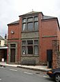
 St. Michael's Church, Bowness-on-Solway |
|

Bowness-on-Solway
|
|
| Population | 1,126 (2011) |
| OS grid reference | NY220623 |
| Civil parish |
|
| Unitary authority |
|
| Ceremonial county | |
| Region | |
| Country | England |
| Sovereign state | United Kingdom |
| Post town | WIGTON |
| Postcode district | CA7 |
| Dialling code | 01697 |
| Police | Cumbria |
| Fire | Cumbria |
| Ambulance | North West |
| EU Parliament | North West England |
| UK Parliament |
|
Bowness-on-Solway is a small village in Cumbria, England. It is located west of Carlisle. The village sits on the southern side of the Solway Firth. This is a wide river mouth that separates England from Scotland. In 2011, about 1,126 people lived here.
Bowness-on-Solway is famous for being the western end of Hadrian's Wall. This ancient Roman wall once stretched across England. Today, you can't see the wall itself above ground here. However, a special pavilion marks the end of the Hadrian's Wall Path. This walking trail follows the wall's route. The village is also part of the beautiful Solway Coast Area of Outstanding Natural Beauty.
Contents
What Does "Bowness" Mean?
The name 'Bowness' describes the shape of the land. It means 'rounded' or 'bow-shaped headland'. This name likely comes from old words. It could be from the Old English words 'boga' (bow) and 'næss' (headland). Or, it might come from the Old Norse words 'bogi' and 'nes'.
Bowness-on-Solway in Roman Times
Bowness-on-Solway was once a very important place for the Romans. A large Roman fort called Maia was built here. It was the second biggest fort along Hadrian's Wall. Outside the fort's south gate, there was also a small civilian settlement. This was a village where people who weren't soldiers lived.
How Bowness-on-Solway is Governed
Bowness-on-Solway is part of the Workington area. This area elects a Member of Parliament (MP) to the UK Parliament. The MP represents the local people in government.
For local matters, Bowness-on-Solway is part of the Cumberland unitary authority area. This local council helps manage things like schools and roads in the area.
St. Michael's Church: A Story of Bells
The village church, St. Michael's Church, has a long history. It might have been built on the site of a Roman granary. A granary was a building used to store grain.
The church has a fun story about its bells. In 1626, raiders from across the border stole the church's two original bells. But they accidentally dropped them into the Solway Firth while escaping! To get even, the villagers of Bowness raided two Scottish villages, Dornock and Middlebie. They returned with a new pair of bells. Even today, the vicar (church leader) of Annan in Scotland traditionally asks for his bells back when they start their job.
The Solway Viaduct: A Railway Bridge
In 1869, a railway bridge called the Solway Viaduct was built. This bridge was very long, about 2.1 kilometers (1.1 miles). It connected the railway in England to the Scottish railway system. This made it easier to travel between the two countries. The bridge was made of iron and crossed the Solway Firth.
Building the viaduct changed things for nearby Port Carlisle. Ships could no longer easily enter the upper Solway. This hurt the trade of Port Carlisle.
The viaduct faced some challenges. It was damaged by frost in 1875. Then, in 1881, large parts of it were destroyed by ice. But the bridge was rebuilt. However, the railway never became as busy as people hoped. In 1914, it was only used for carrying goods. By 1921, the railway closed completely. The viaduct was taken down in 1934. You can still see some parts of it today.
Images for kids
-
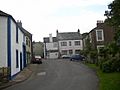
Bowness main street
-
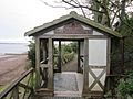
Pavilion at the west end of the Hadrian's Wall Path
-
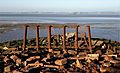
Remains of Solway viaduct - English side 2018
-
The station building in 1961
-
Lindow Hall, Bowness


_1868182_c14d22bb.jpg)

