
Mais (Bowness) facts for kids
Quick facts for kids Maia |
|
|---|---|

Village centre of Bowness-on-Solway, and site of Maia
|
|

Location in Cumbria
|
|
| Known also as | Bowness-on-Solway |
| Location | |
| Coordinates | 54°57′04″N 3°12′43″W / 54.951°N 3.212°W |
| Town | Bowness-on-Solway |
| County | Cumbria |
| Country | England |
| Reference | |
| UK-OSNG reference | NY223626 |
Maia, also called Mais, was an important Roman fort located in Cumbria, England. Today, this area is known as Bowness-on-Solway. Maia was built on Hadrian's Wall, which was a huge defensive barrier across northern Britain. It was either the very first or the very last fort at the western end of the Wall, looking out over the Solway Firth.
Contents
What Was the Fort Called?
Ancient Roman records give us different names for this fort. The Ravenna Cosmography, an old Roman list of places, calls it Maia. Other items like the Rudge Cup, the Amiens Skillet, and the Staffordshire Moorlands Pan call it Mais. Another name, Maio, also appears in the Ravenna Cosmography and might be the same fort.
The name Maia means "The Larger". This makes sense because Maia was the second largest fort on Hadrian's Wall. The biggest fort was Uxelodunum, which was located nearby in Stanwix, Carlisle.
Where Was Maia Located?
The Maia fort was built on a tall sea-cliff, more than 50 feet high. This cliff rose steeply from the shore, giving the Romans a great view of the surrounding land and coastline. The modern name 'Bowness' means 'rounded headland', which describes this excellent defensive spot. The fort was built right over the site of an earlier structure called the eightieth milecastle.
How Was the Fort Built?
When it was first built, Maia fort had walls made of turf and clay. This was similar to how parts of Hadrian's Wall were first constructed. Later, when the Wall was rebuilt using stone, the Maia fort was also rebuilt with strong stone walls.
How Big Was Maia Fort?
Historians believe the fort measured about 710 feet long by 420 feet wide. This means it covered an area of about 7 acres, which is roughly the size of seven football fields! As mentioned, it was the second largest fort on Hadrian's Wall, after the one at Stanwix (Uxelodunum).
Hadrian's Wall came up to the fort from the east and joined it at the northeast corner. The Wall then continued from the northwest corner. It's not completely clear where the Wall went after that. Some old stories say that a lot of stone was found on the beach about 250 yards west of the fort. This might mean the Wall extended all the way down to the low-tide mark, just like it did at Segedunum at the eastern end of the Wall.
Over many years, the cliff face where the fort stood has been worn away by the sea. Because of this, the entire north wall of the fort collapsed into the sea a long time ago.
Fort Gates and Civilian Life
The fort had three main gates: one on the east, one on the west, and one on the south. The modern road that goes through the village today uses the paths where the east and west gates once stood. There probably wasn't a north gate because the north wall was on the high cliff-tops. If there was one for bringing in supplies from the sea, it has long since fallen into the water.
Outside the fort, to the south, there was a civilian settlement. This was called a vicus. It was a small town where families of soldiers and other people lived and worked. This settlement lined the road leading to another fort at Kirkbride. People lived in this vicus well into the fourth century AD.
Who Guarded Maia Fort?
We don't know a lot of details about the specific soldiers who were stationed at Maia. However, we do know that in the third century, the fort's commander was called a tribune. This usually meant that the fort was home to a large group of about a thousand soldiers, possibly a mix of infantry (foot soldiers) and cavalry (soldiers on horseback).
What Have Excavations Revealed?
Archaeologists have done several digs, or "excavations," at the site of Maia fort to learn more about it.
- In 1930, archaeologists uncovered the southern wall of the fort and found the location of the west gate.
- In 1967, more digging helped them find the western wall of the fort.
- In 1973, even bigger excavations took place. During these digs, they found traces of the original turf and clay western wall. They also found evidence of a timber (wooden) gate-tower, which was part of the fort's early construction.
Images for kids
-
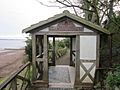
Pavilion at the west end of the Hadrian's Wall Path
-
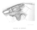
Plan of the fort overlaid on Bowness map from 1857. The coast has eroded since then.


