Carmen, Oklahoma facts for kids
Quick facts for kids
Carmen, Oklahoma
|
|
|---|---|

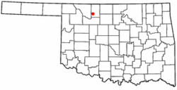
Location of Carmen, Oklahoma
|
|
| Country | United States |
| State | Oklahoma |
| County | Alfalfa |
| Area | |
| • Total | 1.52 sq mi (3.95 km2) |
| • Land | 1.52 sq mi (3.95 km2) |
| • Water | 0.00 sq mi (0.00 km2) |
| Elevation | 1,348 ft (411 m) |
| Population
(2020)
|
|
| • Total | 360 |
| • Density | 236.22/sq mi (91.22/km2) |
| Time zone | UTC-6 (Central (CST)) |
| • Summer (DST) | UTC-5 (CDT) |
| ZIP code |
73726
|
| Area code(s) | 580 |
| FIPS code | 40-12000 |
| GNIS feature ID | 2413170 |
Carmen is a small town located in Alfalfa County, Oklahoma, in the United States. In 2020, about 360 people lived there.
Where is Carmen Located?
Carmen is found along State Highway 45. This highway helps connect the town to other places.
The United States Census Bureau says that Carmen covers an area of about 1.5 square miles (3.9 square kilometers). All of this area is land.
Who Lives in Carmen?
This section shows how the number of people living in Carmen has changed over the years. This is called demographics.
| Historical population | |||
|---|---|---|---|
| Census | Pop. | %± | |
| 1910 | 883 | — | |
| 1920 | 792 | −10.3% | |
| 1930 | 904 | 14.1% | |
| 1940 | 818 | −9.5% | |
| 1950 | 654 | −20.0% | |
| 1960 | 533 | −18.5% | |
| 1970 | 519 | −2.6% | |
| 1980 | 516 | −0.6% | |
| 1990 | 459 | −11.0% | |
| 2000 | 411 | −10.5% | |
| 2010 | 355 | −13.6% | |
| 2020 | 360 | 1.4% | |
| U.S. Decennial Census | |||
As you can see, the population was highest in 1910 and 1930. It has slowly become smaller over time.
Schools in Carmen
Carmen used to share a school district with the nearby town of Dacoma. However, that school is now closed.
See Also
- In Spanish: Carmen (Oklahoma) para niños

Black History Month on Kiddle
Influential African-American Artists:
 | James Van Der Zee |
 | Alma Thomas |
 | Ellis Wilson |
 | Margaret Taylor-Burroughs |

All content from Kiddle encyclopedia articles (including the article images and facts) can be freely used under Attribution-ShareAlike license, unless stated otherwise. Cite this article:
Carmen, Oklahoma Facts for Kids. Kiddle Encyclopedia.
