Carney, Maryland facts for kids
Quick facts for kids
Carney, Maryland
|
|
|---|---|

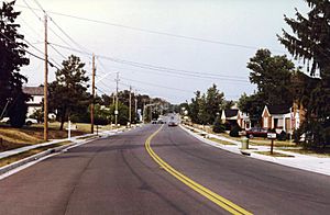
Old Harford Road at Lakewood Drive in Carney, Maryland
|
|

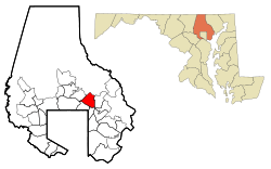
Location of Carney, Maryland
|
|
| Country | |
| State | |
| County | |
| Area | |
| • Total | 7.01 sq mi (18.15 km2) |
| • Land | 7.01 sq mi (18.15 km2) |
| • Water | 0.00 sq mi (0.01 km2) |
| Elevation | 354 ft (108 m) |
| Population
(2020)
|
|
| • Total | 29,363 |
| • Density | 4,191.12/sq mi (1,618.22/km2) |
| Time zone | UTC−5 (Eastern (EST)) |
| • Summer (DST) | UTC−4 (EDT) |
| ZIP codes |
21234, 21236
|
| FIPS code | 24-13325 |
| GNIS feature ID | 0589899 |
Carney is a community in Baltimore County, Maryland, USA. It's not an official city, but a "census-designated place". This means it's an area defined by the government for counting people. In 2020, about 29,363 people lived here.
Contents
Where is Carney Located?
Carney is in Maryland, a state in the USA. It covers an area of about 7 square miles (18 square kilometers). This entire area is land, with almost no water.
Who Lives in Carney?
| Historical population | |||
|---|---|---|---|
| Census | Pop. | %± | |
| 1950 | 1,523 | — | |
| 1980 | 21,488 | — | |
| 1990 | 25,578 | 19.0% | |
| 2000 | 28,264 | 10.5% | |
| 2010 | 29,941 | 5.9% | |
| 2020 | 29,363 | −1.9% | |
| source: | |||
In 2000, there were 28,264 people living in Carney. The community had about 12,083 households. A household is a group of people living together in one home.
Many different people make up Carney. Most residents were White (85.31%). There were also African American (6.92%) and Asian (5.74%) residents. Some people were from other backgrounds too. About 1.51% of the population was Hispanic or Latino.
The average household had 2.28 people. The average family had 2.91 people. About 27.1% of households had children under 18. Many households were married couples (46.2%).
The median age in Carney was 39 years old. This means half the people were younger than 39 and half were older. About 22% of the population was under 18. About 19.4% were 65 or older.
In 2000, the median income for a household was $49,365 per year. For families, it was $57,079. A small number of families (2.8%) and people (5.4%) lived below the poverty line.
Carney's History
How Carney Got Its Name
The community of Carney is named after Thomas Carney. He came to the United States from Ireland in 1880. He bought land in Maryland and started a family.
Around 1885, Thomas Carney opened a general store. It was located where Harford and Joppa roads meet today. This store was also the Carney family home for many years.
Later, the family built a new house nearby. This house was moved in 1933 and is now a real estate office. Over time, the land owned by the Carney family was sold. But their name lives on! The Carney Library and Carney Elementary School are both named after the family.
The Great Carney Fire of 1911
A big fire happened in Carney in 1911. It started when two boys were playing with matches. The fire spread and burned 700 acres of land. This area was between Harford, Joppa, Belair, and Putty Hill Roads.
Firefighters from many nearby towns helped put out the fire. Luckily, no one was killed. Only one firefighter got a sprained ankle.
Education in Carney
Carney has several schools for students. These include:
- Carney Elementary School
- Harford Hills Elementary School
- Seven Oaks Elementary School
- Pine Grove Elementary School
- Perry Hall Elementary School
- Rossville Elementary School
- Pine Grove Middle School
- Perry Hall Middle School
- Loch Raven High School
- Parkville High School
- Perry Hall High School
Getting Around Carney
Main Roads
Some important roads in the Carney area are:
- Joppa Road
- Harford Road (also known as MD-147)
- Old Harford Road
Public Transportation
The Maryland Transit Administration (MTA) has a bus route that serves Carney. Bus Route 54 travels along Harford Road. It connects the Carney Park-and-Ride to Downtown Baltimore.
Images for kids
See also
 In Spanish: Carney (Maryland) para niños
 | William Lucy |
 | Charles Hayes |
 | Cleveland Robinson |


