Carnoy facts for kids
Quick facts for kids
Carnoy
|
|
|---|---|
|
Part of Carnoy-Mametz
|
|

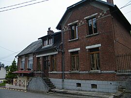
The town hall in Carnoy
|
|
| Country | France |
| Region | Hauts-de-France |
| Department | Somme |
| Arrondissement | Péronne |
| Canton | Albert |
| Commune | Carnoy-Mametz |
| Area
1
|
3 km2 (1 sq mi) |
| Population
(2019)
|
107 |
| • Density | 36/km2 (92/sq mi) |
| Time zone | UTC+01:00 (CET) |
| • Summer (DST) | UTC+02:00 (CEST) |
| Postal code |
80300
|
| Elevation | 79–126 m (259–413 ft) (avg. 86 m or 282 ft) |
| 1 French Land Register data, which excludes lakes, ponds, glaciers > 1 km2 (0.386 sq mi or 247 acres) and river estuaries. | |
Carnoy (pronounced car-nwah in French) is a former village located in the Somme area of northern France. It was once a separate local government area, but on January 1, 2019, it joined with another village to form the new commune of Carnoy-Mametz.
Contents
Where is Carnoy Located?
Carnoy is situated in northern France, about 43 kilometers (around 27 miles) northeast of a city called Amiens. The village is found along a road known as the D254.
How Many People Lived in Carnoy?
Over the years, the number of people living in Carnoy changed. For example, in 1962, there were 72 residents. By 1999, the population was 85. The last recorded population for Carnoy as a separate commune was 107 people in 2019.
| 1962 | 1968 | 1975 | 1982 | 1990 | 1999 | 2006 |
|---|---|---|---|---|---|---|
| 72 | 82 | 74 | 83 | 98 | 85 | 75 |
Carnoy's Role in World War I History
Carnoy played a significant role in the First World War, especially during the famous Battle of the Somme. This battle was one of the largest and deadliest battles in human history.
The Battle of the Somme and Carnoy
The Battle of the Somme began on July 1, 1916. It was a major attack by the British and French armies against the German lines. The area around Carnoy saw very intense fighting during this time.
Explosions at Carnoy
On the very first day of the Battle of the Somme, several large mines were exploded by the British army. These were huge underground tunnels filled with explosives. They were detonated beneath German trenches, creating massive craters. Carnoy was one of the places where these powerful explosions took place.
See also
 In Spanish: Carnoy para niños


