Carreras, Añasco, Puerto Rico facts for kids
Quick facts for kids
Carreras
|
|
|---|---|
|
Barrio
|
|

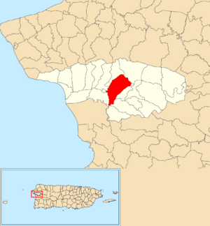
Location of Carreras within the municipality of Añasco shown in red
|
|
| Lua error in Module:Location_map at line 416: Malformed coordinates value. | |
| Commonwealth | |
| Municipality | |
| Area | |
| • Total | 2.52 sq mi (6.5 km2) |
| • Land | 2.50 sq mi (6.5 km2) |
| • Water | 0.02 sq mi (0.05 km2) |
| Elevation | 72 ft (22 m) |
| Population
(2010)
|
|
| • Total | 3,780 |
| • Density | 1,518.1/sq mi (586.1/km2) |
| Source: 2010 Census | |
| Time zone | UTC−4 (AST) |
Carreras is a special area called a barrio in the town of Añasco, Puerto Rico. In 2010, about 3,780 people lived there.
A Look at History
Long ago, after the Spanish–American War in 1898, Spain gave Puerto Rico to the United States. This happened because of a special agreement called the Treaty of Paris of 1898. Puerto Rico then became a territory of the U.S. In 1899, the U.S. government counted all the people in Puerto Rico. They found that Carreras, along with two other areas called Espino and Cidra, had a total of 1,281 people living there.
Here's how the population of Carreras has changed over the years:
| Historical population | |||
|---|---|---|---|
| Census | Pop. | %± | |
| 1950 | 963 | — | |
| 1980 | 1,258 | — | |
| 1990 | 2,010 | 59.8% | |
| 2000 | 3,303 | 64.3% | |
| 2010 | 3,780 | 14.4% | |
| U.S. Decennial Census 1899 (shown as 1900) 1910-1930 1930-1950 1980-2000 2010 |
|||
What are Sectors?
Barrios like Carreras are often divided into even smaller parts. These smaller areas are called sectores (which means sectors in English). Think of them like neighborhoods within a larger area.
There are different kinds of sectores, such as urbanización (a housing development), reparto (a land division), barriada (a neighborhood), or residencial (a residential complex).
One of the sectors found in Carreras barrio is:
- Edificio Paseo del Río
See also
 In Spanish: Carreras (Añasco) para niños
- List of communities in Puerto Rico
- List of barrios and sectors of Añasco, Puerto Rico
 | Chris Smalls |
 | Fred Hampton |
 | Ralph Abernathy |

