Carrizo, Arizona facts for kids
Quick facts for kids
Carrizo, Arizona
|
|
|---|---|

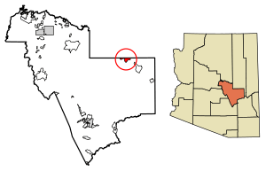
Location of Carrizo in Gila County, Arizona.
|
|
| Country | United States |
| State | Arizona |
| County | Gila |
| Area | |
| • Total | 9.05 sq mi (23.44 km2) |
| • Land | 9.03 sq mi (23.39 km2) |
| • Water | 0.02 sq mi (0.06 km2) |
| Elevation | 4,918 ft (1,499 m) |
| Population
(2020)
|
|
| • Total | 92 |
| • Density | 10.19/sq mi (3.93/km2) |
| Time zone | UTC-7 (Mountain (MST)) |
| ZIP code |
85542
|
| Area code(s) | 928 |
| GNIS feature ID | 2481 |
Carrizo (which is Gaadisóh in the Western Apache language) is a small community in Gila County, Arizona, United States. It is located on the Fort Apache Indian Reservation.
Carrizo is known as a census-designated place. This means it's an area that the government counts for the census. It's not an official city or town with its own local government.
Contents
What's in a Name?
The name "Carrizo" comes from a Spanish word. It means "reeds," which are tall grasses often found near water. People believe the community was named after the Carrizo band of the Apache people.
A Look Back: Carrizo's History
Carrizo is close to the Black River Bridge (Carrizo, Arizona). This bridge is quite old and important. It is even listed on the National Register of Historic Places, which means it's a special historical site.
In 1960, the population of Carrizo was 25 people.
Who Lives in Carrizo?
The number of people living in Carrizo has changed over the years.
| Historical population | |||
|---|---|---|---|
| Census | Pop. | %± | |
| 1960 | 25 | — | |
| 2020 | 92 | — | |
| U.S. Decennial Census | |||
According to the 2010 Census, 127 people lived in Carrizo. Out of these, 125 people were Native American. By the 2020 Census, the population was 92.
Getting Around: Transportation
The White Mountain Apache Tribe helps people get around Carrizo. They run a local bus service called the Fort Apache Connection Transit. This makes it easier for residents to travel within the area.
See also
 In Spanish: Carrizo (Arizona) para niños
 | James Van Der Zee |
 | Alma Thomas |
 | Ellis Wilson |
 | Margaret Taylor-Burroughs |


