Carswell crater facts for kids

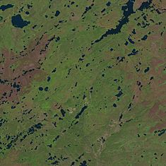
In the northern part the rim is visible as a series of low hills, in the southern part it is indicated by the course of Douglas River. Carswell Lake (in the upper right) cuts into the crater.
|
|
| Impact crater/structure | |
|---|---|
| Diameter | 39 kilometres (24 mi) |
| Age | 115 ± 10 million years (Lower Cretaceous) |
| Exposed | Yes |
| Drilled | Yes |
| Location | |
| Coordinates | 58°26′26″N 109°30′24″W / 58.44056°N 109.50667°W |
| Country | Canada |
| Province | Saskatchewan |
| Topo map | NTS 74K5, 74K6 |
| Access | Saskatchewan Highway 955 |
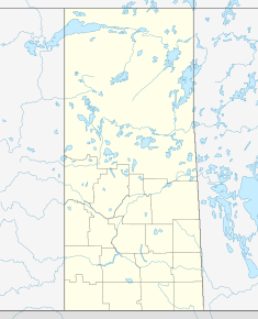
The Carswell crater is a giant bowl-shaped dent in the ground. It's located in northern Saskatchewan, Canada. This huge crater was formed when a large space rock, called a meteoroid, crashed into Earth.
The Carswell crater is about 39 kilometers (24 miles) wide. Scientists believe it was formed around 115 million years ago. This was during a time called the Lower Cretaceous period. That's when dinosaurs were still roaming the Earth! You can see parts of the crater right on the surface today.
Visiting the Carswell Crater
You can reach the Carswell crater by driving on Saskatchewan Highway 955. This road is made of gravel and is about 245 kilometers (152 miles) long. It starts in a village called La Loche. The road ends at an old mine site located right inside the crater.
Important Travel Tips
The mine at Cluff Lake is now closed. This means there are no shops or services nearby. There is also no working airport in the area. If you plan to drive to the crater, make sure you bring enough fuel. You will also need plenty of food and water for your trip. It's important to be prepared for the journey back to La Loche.
 | Aaron Henry |
 | T. R. M. Howard |
 | Jesse Jackson |


