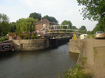
Carthagena Lock facts for kids

Below the lock
|
|
| Waterway | River Lee Navigation |
|---|---|
| County | Hertfordshire Essex |
| Maintained by | British Waterways |
| Operation | Manual |
| Length | 85 feet (25.9 m) |
| Width | 16 feet (4.9 m) |
| Fall | 5 feet (1.5 m) |
| Distance to Bow Creek |
17.5 miles (28.2 km) |
| Distance to Hertford Castle Weir |
8.8 miles (14.2 km) |
| Coordinates | 51°44′37″N 0°00′08″W / 51.743566°N 0.002108°W |
Carthagena Lock (No7) is a special kind of gate system on the River Lee Navigation near Broxbourne. It helps boats move between different water levels. Think of it like a water elevator for boats! This lock is important for boats traveling along the River Lee.
Contents
What is Carthagena Lock?
Carthagena Lock is one of many locks along the River Lee Navigation. It helps boats go up or down a small hill of water. When a boat enters the lock, the water level inside is changed. This allows the boat to continue its journey on the river. The lock is managed by hand, meaning people operate it.
Where is Carthagena Lock?
Carthagena Lock is located in a beautiful area. Right behind the lock, you'll find Carthagena Weir. A weir is like a small dam that controls water flow. This area is also part of a fishery, which means it's a place where fish are raised or caught. There are also two lakes nearby. A part of the old River Lea flows through this area too.
To the east of the lock, there's a group of lakes called Nazeing Mead. These lakes are connected to the Lee Flood Relief Channel. This channel is a special waterway built to help prevent floods by carrying away extra water from the river.
How to Visit Carthagena Lock
It's easy to visit Carthagena Lock and the surrounding area.
Getting There by Car
You can drive to the lock using the B194 Nazeing New Road. There might be places to park nearby.
Walking and Cycling Access
If you enjoy walking or cycling, you can use the towpath. A towpath is a path alongside a river or canal. It was originally used by horses to pull boats. This towpath is part of the Lea Valley Walk, a long trail perfect for exploring the area on foot or by bike.
Public Transport Options
The closest train station is Broxbourne railway station. From there, you might be able to walk or cycle to the lock.

