Carthay, Los Angeles facts for kids
Quick facts for kids
Carthay, Los Angeles
|
|
|---|---|
| Country | |
| State | |
| County | |
| Time zone | Pacific |
| Zip Code |
90035
|
| Area code(s) | 213,323 |
Carthay is a neighborhood in Central Los Angeles, California. It covers about half a square mile. This area includes smaller parts like Carthay Circle, Carthay Square, and South Carthay. Carthay is special because it has three Historic Preservation Overlay Zones. These zones help protect old buildings and the area's history.
Contents
Where is Carthay?
Carthay is a neighborhood made up of three main parts: Carthay Circle, Carthay Square, and South Carthay.
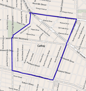
The Los Angeles Times Mapping Project helps us understand where Carthay is. It's bordered by Wilshire Boulevard to the north and Fairfax Avenue to the east. To the south, you'll find Pico Boulevard, and to the west, La Cienega Boulevard. Schumacher and Tower Drives are on its northwest side.
Carthay is surrounded by other neighborhoods. To the north is Beverly–Fairfax. Mid-Wilshire is to the east, and Mid-City is to the south. To the west, you'll find Pico–Robertson. Beverly Hills is also nearby, to the northwest.
Who Lives in Carthay?
In 2000, about 4,866 people lived in Carthay. This means there were about 9,642 people per square mile. This number is about average for Los Angeles. By 2008, the population grew a little to 5,120 people. The average age of people living here was 37, which is a bit older than the city's average.
Carthay is known for being "highly diverse." This means people from many different backgrounds live there. In 2000, the population included:
- 57.8% non-Hispanic white people
- 15.9% Latino people
- 12.8% Black people
- 8.5% Asian people
- 5.1% people of other races
Many residents were born outside the United States. The most common countries of birth were Mexico (26.4%) and Korea (8.2%).
The average household income in 2008 was about $71,398. This was considered a high income for Los Angeles. Many households earned $125,000 or more. The average household size was 2.1 people, which is small for Los Angeles. Most homes (64.7%) were rented, while the rest were owned.
Many adults in Carthay have a college degree. In 2000, about 53.2% of people aged 25 and older had a four-year college degree. This is a high rate compared to the rest of the city and county.
What are Historic Preservation Zones?
Carthay has three special areas called Historic Preservation Overlay Zones (HPOZs). These zones are created to protect the unique history and architecture of certain neighborhoods. They help make sure that new buildings or changes to old ones fit in with the area's original style.
The three HPOZs in Carthay are:
- The Carthay Circle HPOZ
- The South Carthay HPOZ
- The Carthay Square HPOZ
Schools in Carthay
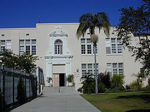
There is one school located within Carthay's borders. It's called Carthay Center Elementary. This school teaches students from kindergarten through sixth grade. You can find it at 6351 West Olympic Boulevard.
In Fall 2014, Carthay Center Elementary became the Carthay School of Environmental Studies Magnet. A "magnet school" is a public school with a special program. This means it focuses on environmental studies. Students who live in the area can still go there. But it also welcomes students from all over the Los Angeles Unified School District who apply for the magnet program. The school's environmental program builds on popular activities like its Garden Science program.


