Casimir Goerck facts for kids
Casimir Theodor Goerck (born around 1755 – died in 1798) was an important surveyor for New York City. From 1788 until his death, he helped map and plan the city's growth. He was related to the famous Roosevelt family through his marriage to Elizabeth Roosevelt. They had two children, Henrietta and Theodore.
Becoming a City Surveyor
Goerck was either from Poland or Germany. He came to America to be an officer in the Continental Army during the American Revolution. He first arrived in New York City in 1785.
That same year, the city's Common Council hired Goerck for a big job. He was asked to survey and lay out streets and lots in the city's "Common Lands." This was a large area, about 1,300 acres, which was about 9% of Manhattan. This land was not near the rivers and was often rocky or swampy. The Council hoped that by adding streets, they could sell these new lots. This would bring much-needed money to the city.
Even with difficult land and simple tools, Goerck finished the job in about six months, by December 1785. He created 140 lots, each about 5 acres in size. He also laid out a main road through the middle. This road would later become Fifth Avenue in the famous Commissioners' Plan of 1811. Goerck's lots were designed with their longest side going east-west, just like the blocks in the later Commissioners' Plan.
Planning Streets for New York
In 1788, the Bayard family, who were related to Peter Stuyvesant, hired Goerck. They wanted him to survey and lay out streets on their land west of Broadway so they could sell it. This area was about 100 acres. Goerck created a grid of 7 east-west streets and 8 north-south streets. Each street was 50 feet wide. This created 35 blocks.
This street grid was one of the first times a grid pattern was used for Manhattan. Many of these streets still exist today in areas like SoHo and part of Greenwich Village. These include Mercer, Greene, Wooster, LaGuardia Place (originally Laurens Street), Thompson, Sullivan, and MacDougal Streets.
By 1794, New York City's economy was getting better. The Council hoped to sell more of the Common Lands. So, they hired Goerck again to survey the area. This time, Goerck was asked to make the lots more regular and rectangular. He also added roads to the east and west of his original middle road. These would later become Fourth and Sixth Avenues in the 1811 plan. He also laid out east-west streets to connect these three north-south roads. These would become the numbered streets of the 1811 plan.
Goerck took two years to finish this task, completing it in March 1796. The Common Lands were now divided into 212 numbered lots, each close to 5 acres. A city official in 1808, John Hunn, said that Goerck's surveys were done "through thickets and swamps, and over rocks and hills where it was almost impossible to produce accuracy." Sometimes, streets that were supposed to meet at right angles didn't quite do so.
Even with these challenges, Goerck's two surveys of the Common Lands provided a basic plan for the Commissioners' Plan of 1811. The New York City Landmarks Preservation Commission has stated that the Commissioners' Plan "borrowed heavily from Goerck's earlier surveys." Historian Gerard Koeppel even called the Goerck plan "modern Manhattan's Rosetta Stone."
The City Map Project
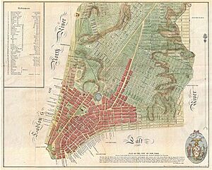
In 1797, the Common Council asked Goerck and French architect Joseph-François Mangin to create a new map of the city. Goerck and Mangin decided to work together. They offered to make a detailed map that went as far north as today's Astor Place. It would show the height of the land, correct old mistakes, and mark every lot, house, street, and wharf.
They asked for 18 months to do the job and wanted $3,000 for their work. They planned to create a large master map, smaller copies, and a book with all the important information. This included the names of property owners. The Council gave them the job.
Goerck died of yellow fever before the map was finished. Mangin completed it on his own. He added new streets, including Mangin Street and Goerck Street, and made other improvements. However, Mangin added more to the map than the Council had asked for. He showed "not the plan of the City such as it is, but such as it is to be." This caused problems, and the map was not fully accepted as the official plan for the city's future.
Death
Casimir Goerck died in 1798. Most sources agree he died in November or December of that year. He passed away from yellow fever, a serious illness spread by mosquitoes. At that time, many New Yorkers died from this disease.
 | Kyle Baker |
 | Joseph Yoakum |
 | Laura Wheeler Waring |
 | Henry Ossawa Tanner |


