Castejón de Alarba facts for kids
Quick facts for kids
Castejón de Alarba, Spain
|
|||
|---|---|---|---|
 |
|||
|
|||
| Country | |||
| Autonomous community | |||
| Province | Zaragoza | ||
| Municipality | Castejón de Alarba | ||
| Area | |||
| • Total | 17.48 km2 (6.75 sq mi) | ||
| Elevation | 916 m (3,005 ft) | ||
| Population
(2018)
|
|||
| • Total | 92 | ||
| • Density | 5.263/km2 (13.63/sq mi) | ||
| Time zone | UTC+1 (CET) | ||
| • Summer (DST) | UTC+2 (CEST) | ||
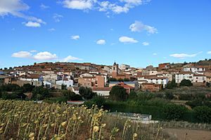
Castejón de Alarba is a small town, also called a municipality, located in the province of Zaragoza. This province is part of Aragon, which is an autonomous community in Spain. In 2004, a count of the people living there, called a census, showed that 98 people lived in Castejón de Alarba. By 2018, the population was 92.
Contents
Where is Castejón de Alarba?
Castejón de Alarba is found in the northeastern part of Spain. It is in the Aragon region, which is known for its beautiful landscapes. The town is part of the province of Zaragoza. This province is named after its largest city, Zaragoza.
What is a Municipality?
A municipality is like a local government area. It includes a town or city and the land around it. Castejón de Alarba is a municipality. This means it has its own local council and mayor. They help manage things like local services for the people living there.
Population and Size
Castejón de Alarba is a very small place. In 2004, only 98 people lived there. By 2018, the number was 92. This makes it one of the smaller municipalities in the Zaragoza province. The total area of the municipality is about 17.48 square kilometers. This is roughly the size of 1,748 football fields.
How High Up is Castejón de Alarba?
The town is located quite high up. Its elevation is 916 meters above sea level. This means it is almost a kilometer higher than the ocean. Being so high up can affect the weather and the types of plants that grow there.
See also

- In Spanish: Castejón de Alarba para niños


