Castle Creek (Washington) facts for kids
Quick facts for kids Castle Creek |
|
|---|---|

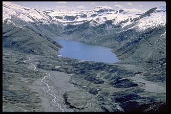
Aerial view of Castle Creek and Castle Lake. Part of Mount St. Helens is visible in the upper left corner of the image.
|
|
| Country | United States |
| U.S. State | Washington |
| County | Cowlitz |
| County | Skamania |
| Physical characteristics | |
| Main source | West flank of Mount St. Helens 4,275 feet 46°13′01″N 122°14′22″W / 46.21690°N 122.23934°W |
| River mouth | North Fork Toutle River 2,200 feet 46°16′59″N 122°17′37″W / 46.28302°N 122.29359°W |
| Basin features | |
| Tributaries |
|
| Waterbodies | Castle Lake (South Fork) |
Castle Creek is a small stream located in Washington state. It flows on the side, or flank, of the famous Mount St. Helens volcano. Castle Creek is a tributary, which means it's a smaller stream that flows into a larger river. It joins the North Fork Toutle River.
Where Castle Creek Starts and Ends
Castle Creek begins high up on Mount St. Helens. Its source, or starting point, is about two miles (three kilometers) northwest of the volcano's crater rim. From there, the creek generally flows towards the northwest.
Joining Other Waters
As Castle Creek flows, it meets other water bodies. The water from Castle Lake flows into Castle Creek. This happens at the north end of the lake. The water from Castle Lake first travels a short distance along a stream called South Fork Castle Creek.
Finally, Castle Creek flows into the North Fork Toutle River. This meeting point is at an elevation of 2,200 feet (about 670 meters).
How Castle Lake Was Formed
Before 1980, the area where Castle Lake is now was known as "Castle Creek Marsh." This was a wet, swampy area.
However, everything changed on May 18, 1980. On that day, Mount St. Helens had a huge eruption. This eruption caused a massive avalanche of rock and debris. This avalanche slid down the mountain and blocked the South Fork Castle Creek. When the creek was blocked, water began to collect behind the blockage, forming the new Castle Lake.
 | Aaron Henry |
 | T. R. M. Howard |
 | Jesse Jackson |


