Castle Lake (Washington) facts for kids
Quick facts for kids Castle Lake |
|
|---|---|

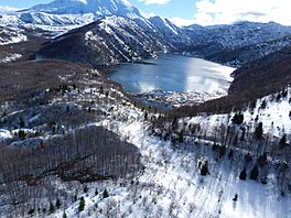
Castle Lake viewed from the air, February 2016
|
|
| Location | Cowlitz County, Washington, US |
| Coordinates | 46°15′01″N 122°16′30″W / 46.25028°N 122.27500°W |
| Type | barrier lake |
| Primary inflows | South Fork Castle Creek |
| Primary outflows | South Fork Castle Creek |
| Catchment area | 8 square kilometres (3.1 sq mi) |
| Basin countries | United States |
| Surface area | 257.7 acres (1.043 km2) |
| Average depth | 18.9 metres (62 ft) |
| Max. depth | 29.78 metres (97.7 ft) |
| Water volume | 21,000,000 cubic metres (740,000,000 cu ft) |
| Surface elevation | 2,595 ft (791 m) |
Castle Lake is a special lake in Washington, USA. It was formed on May 18, 1980, when Mount St. Helens erupted. A huge avalanche from the eruption blocked a creek, creating this new lake. It's a bit hard to get to, but there are trails, and you can even go fishing there! The lake covers just over 1 square kilometer (0.4 square miles). In 1981, a special channel called a spillway was built to help control the water flow.
Contents
About Castle Lake
Castle Lake is a mountain lake, about 9 kilometers (5.6 miles) northwest of Mount St. Helens. It covers an area of just over 1 square kilometer (0.4 square miles). Water from Castle Lake flows into Coldwater Lake, which was also created by the volcano's eruption. The lake is surrounded by steep hills made of volcanic rock.
How Castle Lake Was Formed
On May 18, 1980, Mount St. Helens erupted with incredible power. A massive landslide, about 2.5 cubic kilometers (0.6 cubic miles) of earth and rock, rushed down the mountain. This huge slide blocked the South Fork of Castle Creek.
The blockage created a natural dam, about 20 meters (66 feet) high. Water from the creek then began to collect behind this dam, forming Castle Lake. The blockage itself is quite large, measuring about 610 meters (2,000 feet) long and 430 meters (1,410 feet) wide.
Controlling the Water Level
The lake filled up quickly during the winter of 1980–1981. Experts thought it might overflow the natural dam. To prevent this, a special channel called a spillway was built in October 1981. This spillway is 270 meters (886 feet) long and 30 meters (98 feet) wide.
At the same time, many trees that had been blown into the lake by the eruption were cleared out.
Fish in the Lake
In 1991, rainbow trout started appearing in Castle Lake. They likely swam there from Coldwater Lake, where fish had been introduced a few years earlier. These trout now live and reproduce successfully in Castle Lake, making it a good spot for fishing.
Fun Things to Do at Castle Lake
Since 1989, there has been a trail called the Castle Lake Trail (Trail number 221) in the Gifford Pinchot National Forest. This trail makes it easier for people to visit the lake. If you enjoy fishing, you can go trout fishing there during certain times of the year.
Keeping the Lake Safe
Scientists have been concerned that the natural dam holding back Castle Lake could break. If it broke suddenly, it could cause a flood in nearby towns like Castle Rock, Kelso, Longview, and Toutle.
The United States Army Corps of Engineers studied this risk. They found that the chance of the dam breaking due to water overflowing it is very low. However, the way this dam was formed is very unusual, so there isn't much past information to compare it to. Scientists are still studying how stable the dam is, especially if there's an earthquake or a lot of rain.
 | Stephanie Wilson |
 | Charles Bolden |
 | Ronald McNair |
 | Frederick D. Gregory |


