Castlereagh, New South Wales facts for kids
Quick facts for kids CastlereaghSydney, New South Wales |
|||||||||||||||
|---|---|---|---|---|---|---|---|---|---|---|---|---|---|---|---|

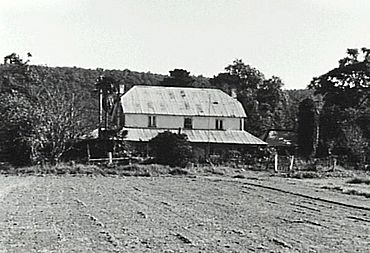
Hadley Park, c. 1810
|
|||||||||||||||
| Population | 1,171 (2016 census) | ||||||||||||||
| Established | 1810 | ||||||||||||||
| Postcode(s) | 2749 | ||||||||||||||
| Elevation | 31 m (102 ft) | ||||||||||||||
| Location | 67 km (42 mi) north-west of Sydney CBD | ||||||||||||||
| LGA(s) | City of Penrith | ||||||||||||||
| State electorate(s) |
|
||||||||||||||
| Federal Division(s) | Lindsay | ||||||||||||||
|
|||||||||||||||
Castlereagh is a suburb located in Sydney, New South Wales, Australia. It's about 67 kilometers north-west of the main city center of Sydney. Castlereagh is part of the City of Penrith area and is found in the wider Greater Western Sydney region.
Contents
History of Castlereagh
Castlereagh is a very old and important place in Australia's early history. It was one of the five original "Macquarie Towns." These towns were officially created by Governor Lachlan Macquarie on December 6, 1810.
Governor Macquarie wrote in his journal that he named the town "Castlereagh" to honor Lord Viscount Castlereagh. This Lord Castlereagh was an important government official in Britain at the time. The official order for the town was given on December 15, 1810.
Early Buildings and Farms
One of the first European buildings in the area was Hadley Park. It was built around 1806 for Charles Hadley, who received a special land grant in 1803. This old house is still standing today and is very well preserved. It's considered a very important historical building. Hadley Park is listed on the New South Wales State Heritage Register.
Another important old building is Nepean Park, built around 1822. It was constructed by people who were convicts at the time, for a man named John Single. This large farmhouse is built in the old Georgian style. It is also listed on the NSW State Heritage Register.
The Castlereagh Post Office opened in 1857 but closed in 1967.
Even after more than 200 years, the rich land near the Nepean River is still used for farming. Many of the first families who settled in the Penrith area came from Castlereagh. The suburb's history is still seen in its many old farmhouses, barns, churches, and cemeteries.
Heritage Sites
Castlereagh has several places that are protected for their historical importance. These include:
- Castlereagh Road: Upper Castlereagh Public School
- 14-278 Old Castlereagh Road: Hadley Park
People of Castlereagh
According to a census in 2016, there were 1,171 people living in Castlereagh. Most people, about 78.8%, were born in Australia. Also, 82.6% of people spoke only English at home. The most common religions reported were Catholic (39.4%) and Anglican (21.3%). About 13.7% of people said they had no religion.
Getting Around Castlereagh
Castlereagh Road is a key road in Sydney. It helps connect the Hawkesbury and Penrith areas, making it an important route for travel.
Schools in Castlereagh
The area has historic public school buildings. The Upper Castlereagh Public School and its old residence were built between 1878 and 1879.
There is also a school called The Lakes Christian College. This school teaches students from kindergarten all the way to Year 12. Another primary school in the area is Castlereagh Public School, which used to be known as Lower Castlereagh Public School.
Sports in Castlereagh
Nepean Speedway is a place where motorcycle speedway races happen. It's located about 3 kilometers north of Castlereagh. The track is 390 meters long. This venue has hosted important motorcycle speedway events, including qualifying races for the Speedway World Championship. It has also hosted the final race for the New South Wales Individual Speedway Championship twice.
 | Toni Morrison |
 | Barack Obama |
 | Martin Luther King Jr. |
 | Ralph Bunche |


