
Cato (community), Wisconsin facts for kids
Quick facts for kids
Cato, Wisconsin
|
|
|---|---|

Downtown Cato
|
|

Cato (community), Wisconsin
Location in Wisconsin

Cato (community), Wisconsin
Location in the United States
|
|
| Country | |
| State | |
| County | Manitowoc |
| Elevation | 260 m (850 ft) |
| Time zone | UTC-6 (Central (CST)) |
| • Summer (DST) | UTC-5 (CDT) |
| Area code(s) | 920 |
| GNIS feature ID | 1562813 |

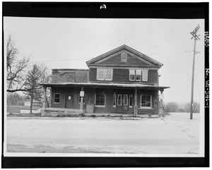
Cato is a small, unofficial community in Manitowoc County, Wisconsin, United States. It's not a city or a town with its own government. Cato is located about 2 miles (3.2 km) west of Whitelaw, Wisconsin, right on U.S. Route 10. This important road has changed the community over the years.
Contents
A Look at Cato's Past
How Cato Got Its Name
Cato was first called Nettle Hills. This was because of all the itchy nettle plants that grew there. Later, settlers renamed the area after a place they knew, Cato (village), New York.
Train Station Days
For many years, Cato was an important stop on a train line. This line connected Manitowoc to Forest Junction. Back then, about eight trains passed through Cato every single day! This made it a busy little hub.
Community Buildings
Cato had its own school that taught local kids from the early 1900s until the 1930s. There was also a Presbyterian church that served the community until the 1960s. One of the longest-lasting buildings was the post office, which operated for 128 years!
Changes from U.S. Route 10
In 1992, a big project started to make U.S. Route 10 better. To do this, some land and several buildings in downtown Cato had to be bought and taken down. This meant that some of the older, historic buildings in the community were removed to make way for the highway improvements.
