
Cavenders Creek (Chestatee River tributary) facts for kids
Cavenders Creek is a small stream located in Georgia. It flows into the Chestatee River, which means it's a "tributary" – like a smaller river joining a bigger one. Cavenders Creek is about 3.43 miles (5.52 kilometers) long.
Where Cavenders Creek Flows
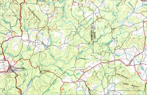
Cavenders Creek starts in the eastern part of Lumpkin County. This starting point, called its "source," is about 2 miles southeast of another stream called Tate Creek. It's also west of major roads like U.S. Route 19, State Route 9, and State Route 60. The creek begins just south of the Chattahoochee-Oconee National Forest.
The creek flows south for about 1.9 miles (3.1 kilometers), running alongside the highway. Along the way, two smaller streams join it from the east. After this, it meets with a stream called Left Fork Cavenders Creek. From there, Cavenders Creek turns southeast and flows for another 1.4 miles (2.3 kilometers). Finally, it joins the Chestatee River north of State Route 52.
Understanding the Cavenders Creek Area
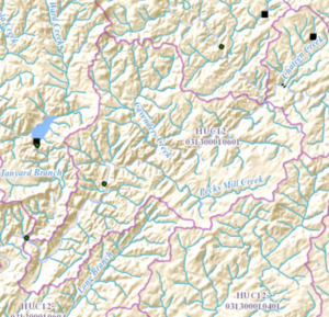
The area of land that collects water for Cavenders Creek and the nearby Chestatee River is called a "watershed." Think of it like a giant bowl where all the rain and melting snow eventually flow into these streams. The United States Geological Survey (USGS) has a special way to identify these areas, and this particular watershed is known as HUC 031300010601. It's officially named the Cavenders Creek-Chestatee River sub-watershed.
This watershed covers about 21 square miles (54 square kilometers) northeast of Dahlonega. The Chestatee River cuts through this area, flowing from the northeast to the southwest. The part of the watershed south of Cavenders Creek and the Chestatee River collects water from the eastern side of Lumpkin County, near Dahlonega.
Many smaller streams feed into the Chestatee River within this watershed. From the south, five unnamed streams and a stream called Pecks Mill Creek (which is about 4.29 miles or 6.90 kilometers long) flow into the Chestatee. From the north, Cavenders Creek and three other unnamed streams also join the river.
