Cazadero, California facts for kids
Quick facts for kids
Cazadero
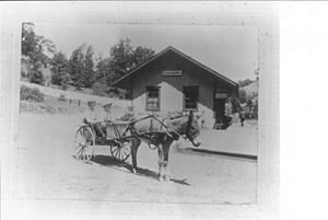
Ingram's Station
|
|
|---|---|

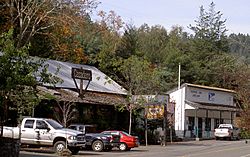
Cazadero in November, 2009
|
|
| Country | |
| State | |
| County | Sonoma |
| Area | |
| • Total | 7.12 sq mi (18.43 km2) |
| • Land | 7.12 sq mi (18.43 km2) |
| • Water | 0.00 sq mi (0.00 km2) 0.02% |
| Elevation | 118 ft (36 m) |
| Population
(2020)
|
|
| • Total | 298 |
| • Density | 41.88/sq mi (16.17/km2) |
| Time zone | UTC-8 (PST) |
| • Summer (DST) | UTC-7 (PDT) |
| ZIP code |
95421
|
| Area code(s) | 707 |
| FIPS code | 06-12146 |
| GNIS feature ID | 220749 |
| Website | https://www.cazadero-csd.org/ |
Cazadero is a small community in western Sonoma County, California. Its name means "hunting ground" in Spanish. In 2020, about 298 people lived here.
The town center has a few important buildings. These include two churches, a general store, and a post office. There's also a hardware store and a fire department.
Cazadero is located where Austin Creek meets the Russian River. This is near the intersection of California State Route 116 and Cazadero Highway. The town itself is about 6 miles (9.7 km) from Route 116. Cazadero Highway runs alongside Austin Creek. This creek is a main branch of the lower Russian River.
The area is also part of the Sonoma Coast AVA, which means it's known for its wine. It's considered part of Wine Country.
Contents
History of Cazadero
Cazadero was once the end point of the North Pacific Coast Railroad. This railroad was built in the 1870s with narrow tracks. Smaller logging railroads and trails brought trees to Duncans Mill. There, the wood was processed and sent south to San Francisco.
Many people believe that much of San Francisco was rebuilt using redwood and other wood from Cazadero. This happened after the big earthquake and fire in April 1906. Wood from Cazadero was also used to build the old eastern part of the San Francisco–Oakland Bay Bridge. This bridge section was replaced in 2013.
Geography and Nature
Many smaller creeks in Cazadero flow into Austin Creek. Austin Creek then flows into the Russian River. Kidd Creek is a main branch in the area. It starts on the slopes of Pole Mountain, which is about 2,204 feet (672 meters) high. This mountain is only a few miles from the Pacific Ocean.
Kidd Creek flows west to east in two main parts. These parts join near the CazSonoma Inn. Then, they flow into Austin Creek about 3 miles (4.8 km) south of town. The land rises quickly from the coast to the mountains west of Cazadero. This means the area gets a lot of rain. Pacific storms bring clouds full of ocean moisture.
Cazadero gets about 85 inches (216 cm) of rain each year. It is thought to be the second-wettest town in California. Only Gasquet gets more rain.
According to the United States Census Bureau, Cazadero covers an area of 7.1 square miles (18.4 square kilometers). Almost all of this area is land. The local ZIP Code covers a much larger area, about 216 square miles (559 square kilometers).
Cazadero's Climate
Cazadero has two types of local climates. One is a cool coastal climate. In summer, highs are in the 70s °F (20s °C). In winter, lows are in the 40s °F (4-9 °C). The other is a warm coastal climate. Here, summer highs can reach the 80s and 90s °F (27-37 °C).
| Climate data for Cazadero, California | |||||||||||||
|---|---|---|---|---|---|---|---|---|---|---|---|---|---|
| Month | Jan | Feb | Mar | Apr | May | Jun | Jul | Aug | Sep | Oct | Nov | Dec | Year |
| Mean daily maximum °F (°C) | 56.9 (13.8) |
60.1 (15.6) |
63.7 (17.6) |
67.8 (19.9) |
74.5 (23.6) |
76.9 (24.9) |
81.0 (27.2) |
83.9 (28.8) |
82.7 (28.2) |
75.9 (24.4) |
64.4 (18.0) |
56.2 (13.4) |
70.3 (21.3) |
| Mean daily minimum °F (°C) | 38.7 (3.7) |
40.2 (4.6) |
41.6 (5.3) |
43.5 (6.4) |
47.3 (8.5) |
50.8 (10.4) |
52.6 (11.4) |
51.2 (10.7) |
51.0 (10.6) |
47.7 (8.7) |
42.1 (5.6) |
38.6 (3.7) |
45.4 (7.5) |
| Average precipitation inches (mm) | 14.18 (360) |
14.17 (360) |
8.39 (213) |
5.28 (134) |
2.01 (51) |
0.42 (11) |
0.20 (5.1) |
0.30 (7.6) |
0.84 (21) |
4.25 (108) |
10.64 (270) |
17.03 (433) |
77.71 (1,973.7) |
| Average snowfall inches (cm) | 0.1 (0.25) |
0.3 (0.76) |
0.0 (0.0) |
0.0 (0.0) |
0.0 (0.0) |
0.0 (0.0) |
0.0 (0.0) |
0.0 (0.0) |
0.0 (0.0) |
0.0 (0.0) |
0.0 (0.0) |
0.3 (0.76) |
0.7 (1.77) |
| Source: WRCC | |||||||||||||
People of Cazadero
| Historical population | |||
|---|---|---|---|
| Census | Pop. | %± | |
| 2010 | 354 | — | |
| 2020 | 298 | −15.8% | |
| 2021 (est.) | 351 | −0.8% | |
| US Census | |||
In 2010, the population of Cazadero was 354 people. By 2020, it had decreased to 298 people. Most people in Cazadero are White. There are also people of Hispanic or Latino background, Native American, and Asian backgrounds. Some people identify with two or more races.
About 17% of the population is under 18 years old. The median age in Cazadero is about 46.7 years. This means half the people are younger than 46.7 and half are older.
Most people in Cazadero own their homes. About 66% of homes are owner-occupied. The rest are rented.
Fun and Recreation
Cazadero is home to several camps. These include:
- BSA Camp Royaneh
- Camp Cazadero
- The Cazadero Performing Arts Camp
See also
 In Spanish: Cazadero (California) para niños
 | Jessica Watkins |
 | Robert Henry Lawrence Jr. |
 | Mae Jemison |
 | Sian Proctor |
 | Guion Bluford |


