Cañada Gobernadora facts for kids
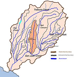
Cañada Gobernadora is a creek in southern Orange County, California. It's like a smaller stream that flows into a bigger one, which is called San Juan Creek. This creek is about 8.5 miles (13.7 kilometers) long.
Cañada Gobernadora starts in the hills of the Santa Ana Mountains. It flows south through neighborhoods, farms, and wild areas. Finally, it joins San Juan Creek near the city of San Juan Capistrano.
The top part of the creek flows through golf courses. It has been shaped by people to control its flow. The lower part is a wide, dry riverbed that can be up to 700 feet (210 meters) across. The creek also gets some water from homes and streets in the nearby communities.
Contents
What is Cañada Gobernadora?
Cañada Gobernadora is a natural waterway. It plays an important role in the local environment. The name means "Canyon of the Governor's Wife" in Spanish. Another old name for the creek refers to a plant called greasewood, which used to grow a lot here.
Where Does the Creek Start and End?
The creek begins high up in the Santa Ana Mountains. This is about 1,040 feet (317 meters) above sea level. From there, it travels south. It ends when it meets San Juan Creek. This meeting point is close to the city of San Juan Capistrano.
How Does the Creek Look?
The upper part of Cañada Gobernadora flows through golf courses. Here, the creek's path has been changed by engineers. The lower part of the creek is much wider. It looks like a dry riverbed, sometimes as wide as 700 feet (210 meters). This part usually only has water after it rains a lot.
Water Sources and Surroundings
The creek gets some water from rain and from nearby neighborhoods. This water is called "urban runoff." The land around the creek has different types of rocks and soil. These include older rock layers and newer sand and dirt. The creek's valley is quite narrow.
Cañada Gobernadora also acts like a natural border. Most of the towns and buildings are on the west side of the creek. On the east side, you'll find more farms and undeveloped land.
History of the Cañada Gobernadora Valley
Long ago, the valley of Cañada Gobernadora was home to the Acjachemen Native Americans. They had two villages along the creek. One of these villages was right where Cañada Gobernadora meets San Juan Creek.
Early Settlement and Mission Plans
This village at the creek's meeting point was once considered for a very important building. It was a possible location for Mission San Juan Capistrano. However, the mission was eventually built in the city of the same name. The Acjachemen people lived here for many years before the Spanish arrived.
Modern Land Use
Today, the areas higher up the creek are mostly covered by suburban neighborhoods. This means there are many homes and communities. The middle and lower parts of the creek's valley are mostly used for farming.
 | May Edward Chinn |
 | Rebecca Cole |
 | Alexa Canady |
 | Dorothy Lavinia Brown |


