Cedar Hill (New Haven) facts for kids
Cedar Hill is a neighborhood in New Haven, Connecticut. It is part of larger areas like East Rock, Quinnipiac Meadows, and Mill River. The name "Cedar Hill" comes from the many cedar trees that grew there in 1665. In the 1960s, the building of I-91 separated Cedar Hill from nearby areas.
Contents
A Look Back: Cedar Hill's History
Early Days and First Settlers
One of the first European settlers in Cedar Hill was David Atwater. He lived in the area, which was then called the East Farm. David Atwater passed away in 1692. He was the first person in the New Haven Colony to be named a "freeman" of the united colony. His farm was located in a spot called the "Neck," which is between the Mill and Quinnipiac Rivers.
Growing Up in the 1800s
For a long time, Cedar Hill was mostly undeveloped. It didn't start to grow much until the mid-1840s. A map from 1851 shows only about a dozen houses and shops. Most of these buildings were along the main roads, which are now called State Street and Middletown Avenue.
Some of the early residents included families like the Atwaters. Major Lyman Atwater, for whom Lyman Street is named, lived here with his son. Grace Street in Cedar Hill is named after Grace Atwater, who married Elias B. Bishop.
In 1818, a special plant called Asclepias lanceolata (now Asclepias viridiflora) was found in Cedar Hill. It was discovered by Dr. Eli Ives.
From the late 1860s to the 1890s, more homes were built, especially near where State Street and Middletown Avenue meet.
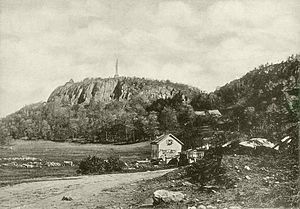
Rock Street, which leads into East Rock Park, was built around 1875. It was first known as the "Highway to the top of East Rock." Charles Warren and Charles Blatchley helped build this road. Warren Place in Cedar Hill is named after Charles Warren.
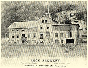
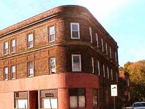
An important business in the area was the Rock Street Brewing Company, owned by George Basserman. This brewery was named after Snake Rock, which is part of East Rock. Basserman also owned an apartment building next to the brewery, which you can still see today. The brewery later caught fire in the 1930s.
Until the late 1800s, Cedar Hill was actually part of Hamden. But when the large railyards were built, it became part of New Haven's Fair Haven neighborhood.
The 1900s and Beyond
A big change in Cedar Hill during the early 1900s was the building of the Cedar Hill Yard. This huge railyard was built between State Street and Middletown Avenue. It started in 1909 as part of a plan by the New York, New Haven and Hartford Railroad.
The Cedar Hill Yards were massive, with 14 different yards out of 25 in New Haven at the time. They could hold over 15,000 train cars! The building where trolleys were once stored is now the Connecticut Transit Bus Terminal. Even though the railyards are mostly empty now, they are still a major part of central Cedar Hill.
Many houses were built on Grace, May, and Cedar Hill Avenues during this time. These homes were for the workers in the growing factories of the nearby Fair Haven neighborhood.
The National Folding Box & Paper Co. was a large factory on James Street. It was a four-story building, over 240,000 sq ft (22,000 m2) in size, and employed many people.
The look of Cedar Hill hasn't changed much since the late 1940s. You can still see old brick buildings like the Michael W. Ferrell Building at 1296-1304 State Street. Another great example is the John H. Slator Building at 1515-1517 State Street, which is an old home from the late 1800s and is now a registered historical home.
Cedar Hill Today
Until 2002, Cedar Hill was part of New Haven's Fair Haven District. However, after the 2000 census, residents voted to become part of the East Rock district. This change happened because New Haven had to redraw its congressional districts before the 2002 elections.
Streets of Cedar Hill
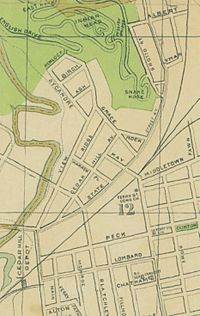
When I-95 was built in the 1950s, some streets in Cedar Hill were removed. This construction made the community feel separated from its neighbors. Other New Haven communities like Mill River, City Point, and part of The Annex were also affected in a similar way.
Here are some of the streets in Cedar Hill:
- Welton Street
- Lyman Street
- Albert Street
- Grace Street
- Rock Street
- Ridge Street
- Warren Street
- State Street
- May Street
- Willow Street (which turns into Blatchley near the Cedar Hill Line)
- A small part of James Street
Some streets were partly removed, like Cedar Hill Avenue, View Street, and some homes on State and Willow. Streets that were completely removed include Hemlock Street, Sycamore Street, Ash Street, Birch Street, and Grotto Street.
Important Landmarks
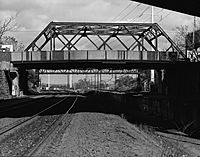
- Ferry Street Railroad Bridge is a good example of a 20th-century truss bridge. It was built by Boston Bridge Works and was part of big improvements to the New Haven Railroad's freight system in Cedar Hill.
* Between 1910 and 1913, the railroad built the large Cedar Hill Terminal to handle more freight. This meant they needed to widen the tracks and add electricity. The city of New Haven paid a small part for a temporary bridge during construction, but the railroad paid for most of it.
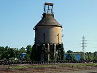
- Cedar Hill Coal Tower was a tall structure in the Cedar Hill Yard used to refuel steam locomotives. It was part of the "hump" where train cars were sorted. The "West Hump" closed in the 1960s, and the "East Hump" closed in 1980.
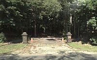
- Bishop Gate is on State Street. It was the start of the first road to the top of East Rock, called the Old Stewart's Road. In 1890, a new road, Indian Head Drive, started at Bishop Gate. Mrs. John Bishop sold much of her land to the parks department for this. Bishop Gate is now closed to cars because of falling rocks, but its two red traprock pillars still mark the start of a great trail for biking and jogging.
- Snake Rock is a large rock formation that provided the stones for Bishop Gate. It's made of trap rock and sandstone. The trap rock covers the eastern side, and the sandstone covers the western side. The sandstone here shows signs of metamorphism, meaning it changed due to heat and pressure.
- English Gate was also built in 1890 using local stones. It's located where Rock and View Streets meet English Drive. It was named after Governor James Edward English, who donated a lot of money to help build East Rock Park. English Gate offers the longest and most scenic drive to the top of East Rock.
 | Sharif Bey |
 | Hale Woodruff |
 | Richmond Barthé |
 | Purvis Young |


