Cedar River (New York) facts for kids
Quick facts for kids Cedar River |
|
|---|---|

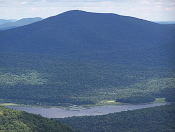
Cedar River from the Wakley Mountain Fire Tower
|
|
|
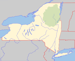
Location of the mouth of the Cedar River
|
|
| Country | United States |
| State | New York |
| Region | Adirondacks |
| Counties | Hamilton, Essex |
| Towns | Arietta, Lake Pleasant, Indian Lake, Minerva, Newcomb |
| Physical characteristics | |
| Main source | Cedar Lake Town of Arietta 2,441 ft (744 m) 43°37′40″N 74°32′18″W / 43.6278447°N 74.5382126°W |
| River mouth | Hudson River NE of Indian Lake (hamlet) 1,463 ft (446 m) 43°51′12″N 74°11′19″W / 43.8533972°N 74.1884813°W |
| Length | 38.5 mi (62.0 km) |
The Cedar River is a river about 38.5 miles (62 km) long. It flows through the central Adirondacks in Hamilton County, New York.
The river starts at Cedar Lake in the town of Arietta. It then flows northeast into Lake Pleasant. Here, it goes through a special area called the Cedar River Flow.
Continuing its journey, the Cedar River passes through the town of Indian Lake. It also touches small parts of Minerva and Newcomb. Finally, it joins the famous Hudson River northeast of the Indian Lake hamlet.
A popular hiking path, the Northville-Placid Trail, follows along the Cedar Lakes and the Cedar River. It goes all the way to the Cedar River Flow.
Exploring the Cedar River Flow
The Cedar River Flow is a remote and shallow lake. It was created by the Wakely Dam. This beautiful area covers about 640 acres (2.6 km²).
The Flow is located about 14 miles (23 km) from the hamlet of Indian Lake. It's a great spot for enjoying nature.
 | Misty Copeland |
 | Raven Wilkinson |
 | Debra Austin |
 | Aesha Ash |


