Cedar Slope, California facts for kids
Quick facts for kids
Cedar Slope, California
|
|
|---|---|

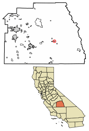
Location of Cedar Slope in Tulare County, California.
|
|
| Country | |
| State | |
| County | Tulare |
| Area | |
| • Total | 0.29 sq mi (0.75 km2) |
| • Land | 0.29 sq mi (0.75 km2) |
| • Water | 0.00 sq mi (0.00 km2) 0% |
| Elevation | 5,584 ft (1,702 m) |
| Population
(2020)
|
|
| • Total | 10 |
| • Density | 34.72/sq mi (13.40/km2) |
| Time zone | UTC-8 (Pacific (PST)) |
| • Summer (DST) | UTC-7 (PDT) |
| GNIS feature ID | 2585406 |
Cedar Slope is a small community located in Tulare County, California. It's called a "census-designated place" because it's a special area defined for counting people. Cedar Slope is high up in the mountains, about 5,584 feet (1,702 m) above sea level.
In 2020, the 2020 United States census counted 10 people living in Cedar Slope. This was a big change from 2010, when no one was officially counted there. You can reach Cedar Slope by driving 37 miles from Porterville on a winding road called California State Route 190. The drive goes up over 5,500 feet!
Contents
Where is Cedar Slope Located?
Cedar Slope is in Tulare County, California. The United States Census Bureau says that this community covers about 0.7 square miles (1.8 square kilometers). All of this area is land.
How Many People Live Here?
The number of people living in Cedar Slope has changed over time.
| Historical population | |||
|---|---|---|---|
| Census | Pop. | %± | |
| 2010 | 0 | — | |
| 2020 | 10 | — | |
| U.S. Decennial Census | |||
- In 2010, the census reported zero people living in Cedar Slope.
- By 2020, the population had grown to 10 people.
The Story of Cedar Slope
The first person known to live in Cedar Slope was an artist named Nellie Marshall. She settled there in 1881. A nearby stream, Marshall Creek, is named after her.
Later, in 1945, two families bought 80 acres of land. These were Les and Ruth Bailey, and Fred and Hazelyn Hopkins. They planned to build a community there. In 1947, Tulare County approved their plans, and the first cabins were built. Many of these early cabins were built by soldiers who had returned from World War Two.
The community also started the Cedar Slope Mutual Water Company in 1947. This company helps manage and provide water for everyone living there.
The Cedar Slope Inn was a local gathering place. It was rebuilt by Carl and Lynn Tapia after the original store burned down in the 1960s. They ran it as a bar and music spot for the community. The Inn was lucky and did not get much damage during a big wildfire later on.
The Sequoia Complex Fire
In September 2020, a large wildfire called the Sequoia Complex Fire caused a lot of damage to Cedar Slope. This fire started naturally.
- Out of 65 cabins in Cedar Slope, 57 were completely burned down.
- Other nearby communities also lost many cabins. Alpine Village lost 37, and Sequoia Crest lost 49.
- The McIntrye Grove of Giant Sequoia trees, which are very old and huge, were also badly damaged by the fire.
Because the fire burned so much of the land, the soil can't soak up water as well as it used to. This means the area is now at risk for dangerous mudslides and flash floods when it rains.
See also
 In Spanish: Cedar Slope para niños
 | Sharif Bey |
 | Hale Woodruff |
 | Richmond Barthé |
 | Purvis Young |


