
Ceiba, Las Piedras, Puerto Rico facts for kids
Quick facts for kids
Ceiba
|
|
|---|---|
|
Barrio
|
|

Puerto Rico Highway 30 in Ceiba
|
|

Location of Ceiba within the municipality of Las Piedras shown in red
|
|

Ceiba, Las Piedras, Puerto Rico
Location in Caribbean
|
|
| Commonwealth | |
| Municipality | |
| Area | |
| • Total | 1.5 sq mi (4 km2) |
| • Land | 1.5 sq mi (4 km2) |
| • Water | 0 sq mi (0 km2) |
| Elevation | 394 ft (120 m) |
| Population
(2010)
|
|
| • Total | 2,500 |
| • Density | 1,666.7/sq mi (643.5/km2) |
| Source: 2010 Census | |
| Time zone | UTC−4 (AST) |
| ZIP Code |
00771
|
Ceiba is a small area, known as a barrio, located in the municipality of Las Piedras, Puerto Rico. In 2010, about 2,500 people lived there. It's a part of Puerto Rico, which is a commonwealth of the United States.
Contents
Discovering Ceiba's Population Growth
Ceiba has seen its population change quite a bit over the years. Understanding these changes helps us learn about the area's history.
How Many People Lived in Ceiba?
The number of people living in Ceiba has grown steadily since the early 1900s. Here’s a quick look at how the population has changed:
- In 1910, there were 401 people.
- By 1920, the population grew to 485.
- In 1930, it reached 564 residents.
- By 1940, 677 people called Ceiba home.
- In 1950, the population was 829.
- By 1980, it had increased to 1,141 people.
- In 1990, there were 1,048 residents.
- The year 2000 saw a jump to 1,557 people.
- By 2010, the population reached 2,500.
This shows that Ceiba has become a home for more and more people over time.
See also
 In Spanish: Ceiba (Las Piedras) para niños
- List of communities in Puerto Rico
Images for kids
-
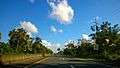
Puerto Rico Highway 30 in Ceiba
-
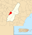
Location of Ceiba within the municipality of Las Piedras shown in red

All content from Kiddle encyclopedia articles (including the article images and facts) can be freely used under Attribution-ShareAlike license, unless stated otherwise. Cite this article:
Ceiba, Las Piedras, Puerto Rico Facts for Kids. Kiddle Encyclopedia.