Center Line, Michigan facts for kids
Quick facts for kids
Center Line, Michigan
|
|
|---|---|

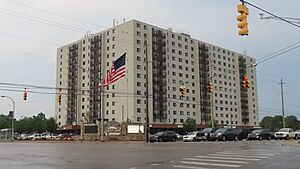
Center Line Park Towers
|
|
| Motto(s):
"Out of the past into the future"
|
|

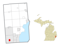
Location within Macomb County
|
|
| Country | |
| State | |
| County | |
| Settled | 1837 |
| Incorporated | 1925 (village) 1936 (city) |
| Area | |
| • Total | 1.75 sq mi (4.54 km2) |
| • Land | 1.75 sq mi (4.54 km2) |
| • Water | 0.00 sq mi (0.00 km2) |
| Elevation | 620 ft (190 m) |
| Population
(2020)
|
|
| • Total | 8,552 |
| • Estimate
(2023)
|
8,354 |
| • Density | 4,773.71/sq mi (1,840.09/km2) |
| Time zone | UTC-5 (Eastern (EST)) |
| • Summer (DST) | UTC-4 (EDT) |
| ZIP Code |
48015
|
| Area code(s) | 586 |
| FIPS code | 26-14320 |
| GNIS feature ID | 0622981 |
Center Line is a city in Macomb County, Michigan, USA. It is a smaller city located near Metro Detroit, which is a big area around Detroit. Center Line is about 11 miles (18 km) north of downtown Detroit. The larger city of Warren completely surrounds it. In 2020, about 8,552 people lived there.
Contents
A Look Back: Center Line's History
Historically, the area where Center Line now stands was mostly swamp and wild land. This was true until the early 1800s. In the early 1800s, people from France, Germany, Belgium, and Ireland moved here. They worked hard to clear the forests and drain the wet lands.
How Center Line Got Its Name
For a while in the mid-1800s, Center Line was called "Kunrod's Corner." Some people believe the French named it "Center Line." It was the middle path of three old Potawatomi trails. These trails went from Fort Detroit to trading posts up north. The "center line" trail led from Detroit to Utica.
Early Community Growth
The community started growing when Catholic settlers built a church. This meant they didn't have to walk all the way to St. Mary's in Detroit for church. This church, called St. Clement's, was built in 1854. It brought more Catholic families to the area.
In 1863, Joeseph Buechel opened the first general store. Later, Hieronymous Engelmann became the first postmaster in 1878. Sophia Buechel took over as postmaster in 1885. The "Centre Line" post office closed in 1906. After that, the name was officially changed back to Center Line.
Becoming a City
In the early 1900s, street car tracks connected Detroit to Center Line. These tracks ran along Van Dyke Road. Ten Mile Road was the last stop for the street car. Center Line became an official village in 1925. It was in the middle of Warren Township, which is now the city of Warren. Center Line then became a city in 1936.
Where is Center Line?
Center Line is located in the southwestern part of Macomb County. The city of Warren completely surrounds it.
Distances to Other Cities
- About 11 miles (18 km) north of downtown Detroit.
- About 7 miles (11 km) west of St. Clair Shores.
- About 6 miles (10 km) east of Royal Oak.
- About 11 miles (18 km) south of Utica.
Major Roads and Highways
Interstate 696 runs along the northern edge of Center Line. You can get on or off from Exits 22 through 24. Highway M-53 (Van Dyke Avenue) goes north and south through the middle of town. It connects Detroit and Utica.
The U.S. Census Bureau states that Center Line covers a total area of 1.75 square miles (4.54 square kilometers). All of this area is land.
People of Center Line
| Historical population | |||
|---|---|---|---|
| Census | Pop. | %± | |
| 1930 | 2,604 | — | |
| 1940 | 3,198 | 22.8% | |
| 1950 | 7,659 | 139.5% | |
| 1960 | 10,164 | 32.7% | |
| 1970 | 10,379 | 2.1% | |
| 1980 | 9,293 | −10.5% | |
| 1990 | 9,026 | −2.9% | |
| 2000 | 8,531 | −5.5% | |
| 2010 | 8,257 | −3.2% | |
| 2020 | 8,552 | 3.6% | |
| 2023 (est.) | 8,354 | 1.2% | |
| U.S. Decennial Census | |||
Population in 2010
According to the census from 2010, there were 8,257 people living in Center Line. These people lived in 3,632 households. About 1,988 of these households were families. The city had about 4,745 people per square mile (1,832 per square kilometer).
Most residents (82.5%) were White. About 12.0% were African American. A smaller number were Asian (2.5%) or Native American (0.4%). About 2.5% of people were of two or more races. People of Hispanic or Latino background made up 1.7% of the population.
Households and Age
About 27.7% of households had children under 18 living with them. Many households (40.2%) were made up of individuals living alone. About 18.1% of these individuals were 65 years old or older. The average household had 2.22 people. The average family had 3.01 people.
The average age in Center Line was 41.2 years. About 21.4% of residents were under 18. About 17.7% were 65 or older. The city had slightly more females (53.9%) than males (46.1%).
Most adults (85.9%) aged 25 or older had a high school degree. About 10.8% of adults aged 25 or older had a bachelor's degree or higher. The average household income was $30,752. About 21.3% of the population lived below the federal poverty line.
Fun Things to Do
Annual Events
The Center Line Independence Festival is a big yearly event. It celebrates the community's independence from Warren, Michigan. It also celebrates the nation's independence. The festival started in 2016 for the city's 80th birthday. It features live bands, a carnival, and arts and crafts. There are also children's activities and local food. A popular fireworks display is always a highlight.
Historical Markers
Center Line has two special Michigan historical markers. These markers show important places. They are located at:
- St. Clement Catholic Church
- St. Clement Catholic Cemetery
Learning in Center Line
Most students in Center Line go to schools in the Center Line Public Schools district. This includes Center Line High School. A small part of the city is in Van Dyke Public Schools. Students there attend Lincoln High School.
Former Catholic Schools
St. Clement Catholic School was in Center Line. It was part of the Roman Catholic Archdiocese of Detroit. The school opened in 1857. It had 110 students in 2009-2010. The school closed in 2011 because student numbers dropped.
The archdiocese also ran St. Clement High School in Center Line. It closed in 2005. Macomb Christian Schools (MCS) used the old St. Clement High School building from 2017 to 2019. MCS then closed down.
Transportation and Roads
Main Highways
 I-696 (Walter P. Reuther Freeway) runs east and west. It is on the north side of the city.
 M-53 (Van Dyke Avenue) goes north and south. It runs from 9 1/2 Mile Road (Stephens) to 11 Mile Road (I-696). This road leads into the Van Dyke Freeway.
Local Roads
East-west travel in Center Line mainly happens on the "mile roads." 10 Mile Road runs through the center of the community. 11 Mile Road is on the northern border, shared with Warren. These roads are part of the Mile Road System (Detroit).
See also
 In Spanish: Center Line para niños
 | Victor J. Glover |
 | Yvonne Cagle |
 | Jeanette Epps |
 | Bernard A. Harris Jr. |


