
Cerisy facts for kids
Quick facts for kids
Cerisy
|
||
|---|---|---|
.JPG) |
||
|
||

Cerisy
Location in France

Cerisy
Location in Hauts-de-France
|
||
| Country | France | |
| Region | Hauts-de-France | |
| Department | Somme | |
| Arrondissement | Amiens | |
| Canton | Corbie | |
| Intercommunality | Val de Somme | |
| Area
1
|
10.93 km2 (4.22 sq mi) | |
| Population
(Jan. 2019)
|
534 | |
| • Density | 48.86/km2 (126.54/sq mi) | |
| Time zone | UTC+01:00 (CET) | |
| • Summer (DST) | UTC+02:00 (CEST) | |
| INSEE/Postal code |
80184 /80800
|
|
| Elevation | 32–92 m (105–302 ft) (avg. 68 m or 223 ft) |
|
| 1 French Land Register data, which excludes lakes, ponds, glaciers > 1 km2 (0.386 sq mi or 247 acres) and river estuaries. | ||

Cerisy is a small town, also called a commune, located in northern France. It is part of the Somme department and the Hauts-de-France region.
A commune is like a local government area in France. It's the smallest division for how the country is organized. Cerisy is a quiet place where people live and work.
Contents
Where is Cerisy Located?
Cerisy is found in the Somme department. This department is in the Hauts-de-France region. This region is in the northern part of France.
Understanding the Somme Department
The Somme department is named after the Somme River. This river flows through the area. The department is known for its history and farming.
Hauts-de-France Region Explained
Hauts-de-France is one of France's largest regions. It was formed in 2016. It combines two older regions: Nord-Pas-de-Calais and Picardy. Cerisy is in the part that used to be Picardy.
Life in Cerisy
Cerisy is a small community. In January 2019, about 534 people lived there. The town covers an area of about 10.93 square kilometers.
Who is the Mayor?
The mayor of Cerisy is Claudie Duthoit. The mayor is the head of the local government. They help manage the town and its services. Mayors are elected by the people living in the commune. Claudie Duthoit's term is from 2020 to 2026.
What is an Intercommunality?
Cerisy is part of an "intercommunality" called Val de Somme. This means Cerisy works with nearby communes. They share resources and services. This helps them manage things like waste or public transport better.
Exploring Cerisy's Landscape
Cerisy is located at an elevation of about 68 meters above sea level. The lowest point in the commune is 32 meters. The highest point is 92 meters. This means the land is a bit hilly.
What is an Arrondissement and Canton?
Cerisy is in the Amiens arrondissement. An arrondissement is a larger administrative area. It groups several cantons together. Cerisy is also in the Corbie canton. A canton is a smaller area used for elections.
Images for kids
-
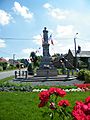
A view of Cerisy
-
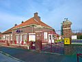
The town hall of Cerisy, where local government works
-
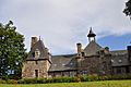
The beautiful Cerisy château
.JPG)


See also
 In Spanish: Cerisy para niños
