
Cerro de San Pedro facts for kids

Cerro de San Pedro is a small village and the main town of its municipality in the Mexican state of San Luis Potosí. It is located in hills, about 5 kilometers (3 miles) northeast of the city of San Luis Potosí.
As of 2005, only 95 people lived in the village. Today, the village is near a large open-pit gold mine, which has changed the landscape.
Contents
Where is Cerro de San Pedro?
The village is in the central part of the state. It is about 2,040 meters (6,693 feet) above sea level.
Cerro de San Pedro borders several other places. These include Soledad de Graciano Sánchez to the north and west, Armadillo de los Infante to the east, and San Luis Potosí city to the southwest. Villa de Zaragoza is to the south. The village is located at 100° 49’ west longitude and 22° 13’ north latitude.
A Look at History
Early Days and Discovery
Long ago, the area was home to the Chichimeca and Guachichil people. These were indigenous groups living in Mexico before the Spanish arrived.
The village began as a Spanish mining settlement. It was formally started in 1592. This place was very important for the state. A picture of its mineral-rich hill is even on the state's coat of arms. Sadly, this famous hill has almost disappeared because of new mining operations.
How Mining Started Here
In 1592, a priest named Diego de la Magdalena met some Guachichil people. One man, named Cualiname, had golden outlines in his face paint. The priest asked where he got this golden powder. Cualiname said there was a lot of it to the east.
The priest told Captain Miguel Caldera about this discovery. Captain Caldera then claimed the land for New Spain. He sent explorers to check for minerals. One explorer, Pedro de Anda, named the place San Pedro del Potosí. He chose this name to honor his saint and remember the famous mines in Potosí, Bolivia.
Gold and silver were found in the hills of San Pedro. However, there was not enough water nearby for mining. Water had to be brought from the north. By 1624, these challenges were overcome. The mines produced a lot of gold and silver for hundreds of years.
Historic Mines in the Area
Many gold and silver mines operated in the Cerro de San Pedro District. Some of them included:
- Mina La Descubridora
- Mina San Pedro Celestial
- Mina Bisnagas
- Mina Barreno
- Mina Socavon Aventurero
- Mina la Victoria
- Mina 5 de Mayo
- Mina San Pedro el Alto
- Mina San Pedro el Bajo
- Mina Catillas (on Bufa Hill)
- Mina Begonia
- Mina Socavon del Rey
- Mina Dorotea
- Mina La Encantada
- Mina La Flor
- Tiro San Pedro
- Tiro Juarez
- Mina Cañon de las Mulas
- Mina Salon Colorado
Main Mine Entrances
The main entrances to the mines were:
- San Pedro shaft
- Juarez shaft
- Begonia shaft
Modern Mining Operations
In the 20th century, different companies ran the mines. One was Metalúrgica Mexicana, part of ASARCO, starting in 1928. In 1948, miners went on strike for better pay and conditions. They did not win, and ASARCO left. Before leaving, they collapsed the main mine tunnels. The mines were never officially declared empty. Later, a Canadian company, Metallica Resources, bought the mines.
In 1997, another Canadian company, New Gold Inc., bought the mines through its Mexican branch, Minera San Xavier (MSX).
The Open Pit Mine
In 1999, the Cerro de San Pedro Mine reopened for gold mining. This time, it was an open pit mine, not an underground one. Many local and national groups strongly opposed this. The open pit mine was in an area that was protected. It was declared a colonial monument zone in 1972 and a wildlife zone in 1993.

In 1997, MSX got permission from local authorities to start the project. In 1999, the Mexican Ministry of Environment (SEMARNAT) gave MSX an environmental permit. After this, a long legal fight began between MSX and groups against the mine.
In 2004, a court said that MSX had used fake signatures to lease land. Also in 2004, the National Defense Secretariat allowed MSX to use explosives. This went against an earlier court order. The National Institute of Anthropology and History (INAH) also sued MSX. They said historical monuments were damaged by the explosives. The nearby historic center of San Luis Potosí city is a World Heritage Site.
Finally, in 2004, the Supreme Tribunal cancelled MSX's environmental permit. They ruled that the permit should never have been given. MSX tried to appeal and kept working. In 2005, their appeal was rejected, and the mine was closed.
In 2006, the Mexican government gave MSX a new environmental permit. This happened after President Vicente Fox publicly supported MSX. In 2010, the Supreme Tribunal cancelled this new permit. The Environment Federal Agency (PROFEPA) closed the mine for a second time.
Despite strong local opposition, SEMARNAT issued MSX a new permit in late 2010. The mine began operating again. About 25 tons of explosives are used daily. The famous hill, Cerro de San Pedro, no longer exists because of the mining.
Cerro de San Pedro Municipality
Towns and Communities
The Cerro de San Pedro Municipality includes several villages and communities:
- Cerro de San Pedro (the main town)
- Portezuelo
- Real del Potosi
- Monte De Caldera
- Cuesta de Campa
- La Zapatilla
- Divisadero
- Calderon
- Jesus Maria
- Joyita de la Cruz
- La Florida
- Granjas de San Pedro
- Granjas de la Florida
- Planta del Carmen
Images for kids
-
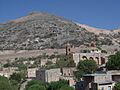
Panorama of Cerro de San Pedro village (right), and the San Pedro Mine behind it.
-
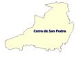
Map of Cerro de San Pedro Municipality
-
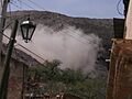
Explosion for open pit mining next to the town.

See also
 In Spanish: Cerro de San Pedro para niños
