Chaloupe River facts for kids
Quick facts for kids Chaloupe River |
|
|---|---|

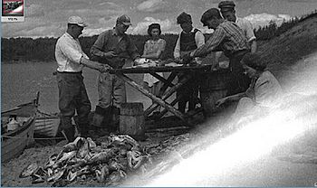
Slicing cod in Rivière-à-la-Chaloupe
|
|
| Other name(s) | Rivière à la Chaloupe |
| Country | Canada |
| Province | Quebec |
| Region | Côte-Nord |
| RCM | Minganie |
| Physical characteristics | |
| River mouth | Gulf of Saint Lawrence 0 metres (0 ft) 50°17′35″N 65°07′19″W / 50.293056°N 65.121944°W |
| Length | 32 kilometres (20 mi) |
| Basin features | |
| Basin size | 201 square kilometres (78 sq mi) |
The Chaloupe River (also known as Rivière à la Chaloupe in French) is a river in the Côte-Nord region of Quebec, Canada. It is about 32 kilometres (20 mi) (20 miles) long. The river flows from north to south and empties into the Gulf of Saint Lawrence.
Contents
Where is the Chaloupe River located?
The Chaloupe River is found in Quebec, Canada. Its mouth is located about halfway between the towns of Sept-Îles and Havre-Saint-Pierre. The river flows through the municipality of Rivière-au-Tonnerre.
Only small boats can travel on the Chaloupe River. It has several smaller rivers that flow into it, like the Guillaume, Vibert, and Robichaud rivers. There is also a small village called Rivière-à-la-Chaloupe located near where the river meets the sea.
What does the name "Chaloupe" mean?
The word chaloupe is French for a small boat, often a fishing boat. People used these types of boats a lot in this area.
How did the river get its name?
In the late 1800s, a visitor named Abbé Huard asked about the name. He was told that the Chaloupe River was bigger than a nearby river called Rivière aux Graines. It was a good place for these small boats to find shelter. There is also a large bog (a type of wetland) nearby called the Grande Plaine de la Chaloupe.
What is the Chaloupe River like?
The Chaloupe River starts about 40 kilometres (25 mi) (25 miles) from where it meets the sea. However, it's hard to travel by canoe because of many waterfalls and fast-moving sections in the last 11 kilometres (6.8 mi) (7 or 8 miles).
What did early explorers say about the river?
An old book from 1914 described the river. It mentioned that local people did not use the river to travel far inland. In winter, people would go to the river's source to find animals for hunting. The land around the river was not very fertile, and the trees were small. The river was known for having many trout.
What is the land like around the river?
Near the Gulf of Saint Lawrence, the land is mostly flat for about 2 kilometres (1.2 mi) (1.2 miles). It then slowly rises to about 100 metres (330 ft) (328 feet) high. This flat area was once covered by ancient seas, which left behind clay and sand.
What are the hills like?
Most of the area around the river has rounded, rocky hills. These hills get taller as you go north, reaching an average height of 400 metres (1,300 ft) (1,312 feet). The highest point is 488 metres (1,601 ft) (1,601 feet) in the northern part. The rocks here are very old, formed from cooled magma deep underground.
How big is the Chaloupe River basin?
The Chaloupe River basin is the area of land where all the water flows into the river. It covers about 201 square kilometres (78 sq mi) (77.6 square miles). Most of this area (about 75%) is in an unorganized territory called Lac-Jérôme. The rest is in the municipality of Rivière-au-Tonnerre.
What are the features of the basin?
The basin is long and narrow, stretching about 26 kilometres (16 mi) (16 miles) from north to south. It is about 10 kilometres (6.2 mi) (6 miles) wide on average. The Chaloupe River basin is located between the Manitou River to the west and the Sheldrake River to the east.
Lake Vibert is the only large lake in the basin, covering about 84.1 hectares (208 acres) (208 acres). The rivers and streams in the basin often follow straight lines or turn at right angles because of cracks in the bedrock. Near the coast, the river winds and meanders through sandy areas. At its mouth, there is a 1 kilometre (0.62 mi) (0.6 mile) long estuary with several channels.
The river drops about 305 metres (1,001 ft) (1,000 feet) from its source to its mouth. The amount of water flowing in the river changes throughout the year, from about 1.6 cubic metres per second (57 cu ft/s) (56 cubic feet per second) to 18 cubic metres per second (640 cu ft/s) (636 cubic feet per second).
What is the environment like?
The average temperature in this area is about 1.1 °C (34.0 °F) (34°F) each year. It also gets a lot of rain and snow, about 1,080 millimetres (43 in) (42.5 inches) annually.
What plants and animals live here?
The forests on the flat coastal plain are mostly made up of black spruce trees. In the hillier areas, you'll find a mix of black spruce and balsam fir trees. In the past, there was a lot of logging in the lower part of the river basin. There was also a major outbreak of hemlock looper moths, which caused many fir trees to lose their leaves.
The river is home to several types of fish, including:
There are no special wildlife areas or parks directly in the river's watershed. However, there is a protected area for water birds near the river's mouth, which includes the estuary.
 | John T. Biggers |
 | Thomas Blackshear |
 | Mark Bradford |
 | Beverly Buchanan |


