
Manitou River (Quebec) facts for kids
Quick facts for kids Manitou River |
|
|---|---|

Falls on Manitou river
|
|

|
|
| Native name | Rivière Manitou |
| Country | Canada |
| Province | Quebec |
| Region | Côte-Nord |
| RCM | Minganie |
| Physical characteristics | |
| Main source | Lac Caobus Lac-Jérôme 584 units? 51°21′06″N 65°27′57″W / 51.35177°N 65.46590°W |
| River mouth | Gulf of Saint Lawrence Rivière-du-Tonnerre 0 metres (0 ft) 50°17′52″N 65°14′29″W / 50.29778°N 65.24139°W |
| Length | 148 kilometres (92 mi) |
| Depth |
|
| Basin features | |
| River system | Gulf of Saint Lawrence |
| Basin size | 2,642 square kilometres (1,020 sq mi) |
| Tributaries |
|
| Waterbodies | Eudist Lake, Lac du Canot, Lake Manitou |
| Waterfalls | Chute à Wallace, |
| Bridges | Route 138 |
| NRC Id | EHDEJ |
The Manitou River (French: Rivière Manitou) is a beautiful river in Quebec, Canada. It flows through a wild, natural area in the Côte-Nord region. The river is known for its amazing waterfalls, especially near where it meets the Gulf of Saint Lawrence.
Even though some people wanted to build power plants on the river, many others worked to protect it. Now, there are ideas to make it a national park or a special reserve. This would help keep the river and its surroundings safe for everyone, including the Innu people who have traditional claims to the land.
Contents
Where the River Flows
The Manitou River starts in a lake called Lac Caobus, in a wild area of Quebec. It then flows south through the Minganie Regional County Municipality. As it travels, the river gets wider in two places, forming two important lakes: Lake Manitou and Eudist Lake.
Finally, the river reaches the Gulf of Saint Lawrence near a small community called Manitou. This spot is about halfway between the cities of Sept-Îles and Havre-Saint-Pierre. The river is about 148 kilometres (92 mi) long. It has a large area of land that drains into it, covering about 2,642 square kilometres (1,020 sq mi).
The river has three main waterfalls that could be used to make electricity. However, plans to build power plants were mostly stopped because people wanted to protect the river's natural beauty.
Meaning of the Name
The name "Manitou" comes from the beliefs of several indigenous people in the area. For them, "manitou" means a powerful spirit or the "great spirit" that represents life. They believed this spirit could be found in waterfalls.
The phrase Tché-Manitou means "good spirit," while Matchi-Manitou means "bad spirit" or "devil." The word "Manitou" is the French version, but English speakers also used similar words like manitto or manitoa. You can find this name in many places across Quebec, even in Inuit areas. The name "Manitou River" was officially recognized on December 5, 1968.
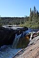
Manitou Falls (Chute Manitou)
.jpg)
Close to where the Manitou River meets the ocean, there's a spectacular waterfall called Chute Manitou. The falls are about 37 metres (121 ft) high, which is like falling from a 12-story building!
There's a special visitor center at Chute Manitou. It has a parking lot and picnic tables, making it a great place to stop and enjoy nature. You can walk on trails through the forest on both sides of the river. One trail, called La Chute, has wooden stairs that lead down to the bottom of the falls. Along the way, you'll find spots to get amazing views of the waterfall from different heights. Part of the trail even goes over a red granite beach. In 2017, the trails were closed for a bit to make them safer and better for visitors.
River Landscape
The area around the Manitou River stretches from north to south. Near the coast, there's a flat plain about 4 kilometres (2.5 mi) wide. Further inland, the land rises into hills and then a large plateau. Mount Manitou, which is part of this area, is very tall, reaching 1,036 metres (3,399 ft) high.
The river flows through different types of rock, including gneiss and granite. In many places, the ground is covered by thin layers of soil and rocks left behind by glaciers. Near the coast, the land was once covered by the Goldthwait Sea after the last ice age. When the sea left, it left behind soft clay and sand.
River Flow and Lakes
The Manitou River and its smaller streams flow in interesting ways. In the northern parts, they often follow straight lines and sharp turns because of cracks in the hard rock. Further south, the river becomes more winding as it flows through old valleys carved by glaciers.
Near the coast, the Manitou River has cut a straight path through the soft ground. The river's mouth forms a bay about 1.1 kilometres (0.68 mi) long. The river flows for about 150 kilometres (93 mi) from north to south, dropping about 640 metres (2,100 ft) in height along the way.
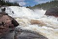
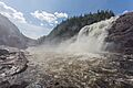
The river has three large waterfalls in its lower section: the Grosse Chute (35 metres (115 ft) high), Aubin Falls, and Wallace Falls. Many smaller rivers and streams flow into the Manitou River, bringing water from different parts of the land.
There are three big lakes in the river's basin:
- Aigle Lake in the north, covering 23.6 square kilometres (9.1 sq mi).
- Lake Manitou in the middle, which is almost 25 kilometres (16 mi) long but only 1–2 kilometres (0.62–1.24 mi) wide. It was formed when an old glacial valley filled with water.
- Eudist Lake in the south, covering 30.2 square kilometres (11.7 sq mi).
Wildlife and Nature

The coastal plain near the river's mouth has many peat bogs, which are wet, spongy areas of land. Further north, you can find more peat bogs and fens (another type of wetland). The forests in this area are mostly untouched, except for a small part that was used for logging a long time ago.
Scientists believe there are about 27 different kinds of fish in the river. While it's not a main salmon river, salmon can sometimes be found in the river's mouth below the falls. The river basin is also a great home for birds, with an estimated 139 species that might nest there. They use the large peat bogs and calm waters. Cliffs near the lakes also provide good places for birds of prey, like eagles and hawks, to live.
A study in 2008 suggested that the river would be a great place for canoeing or kayaking. People could start far upstream and paddle down to Eudistes Lake. This would be a wonderful way to explore the wild beauty of the Manitou River!
Images for kids
-
Falls on Manitou river
-
Waterfall on the river
-
Another of the waterfalls
