
Chamba State facts for kids
Quick facts for kids Chamba State
चम्बा रियासत
|
|||||||
|---|---|---|---|---|---|---|---|
| Princely State of British India | |||||||
| ca 550–1948 | |||||||
 Flag
 Coat of arms
|
|||||||
 1911 map of the Princely States of the Shimla Hills showing the boundaries of Chamba State. |
|||||||
| Area | |||||||
|
• 1892
|
8,099 km2 (3,127 sq mi) | ||||||
| Population | |||||||
|
• 1892
|
115,773 | ||||||
| History | |||||||
|
• Established
|
ca 550 | ||||||
|
• Accession to the Indian Union
|
1948 | ||||||
|
|||||||
| Today part of | Himachal Pradesh, India | ||||||
| Chamba Princely State | |||||||
Chamba State was a very old kingdom in what is now India. It was one of the many "princely states" that existed before modern India was formed. This state was founded around the year 550. It was located high up in the beautiful Himalaya mountains.
Contents
What Was Chamba State?
Chamba State was a special kind of kingdom in India. It was called a "princely state." This meant it had its own ruler, often called a Raja or King. These rulers managed their own areas. However, during the time of the British in India, these states were under British protection. They were not directly ruled by the British. Chamba State was one of the oldest and most important of these states.
Where Was Chamba State Located?
Chamba State was nestled in the Himalaya mountains. This region is known for its stunning natural beauty. It has tall peaks, deep valleys, and flowing rivers. The state was in the northern part of India. Today, this area is part of the Himachal Pradesh state in India. Its mountain location made it somewhat isolated. This helped it keep its unique culture for a long time.
When Was Chamba State Founded?
Chamba State has a very long history. It was founded around the year 550. This means it existed for over 1,300 years! Over these many centuries, different rulers from the same family line governed the state. They built temples, forts, and towns. The state grew and changed over time. But it always kept its distinct identity.
How Did Chamba State Become Part of India?
Chamba State continued to exist until 1948. This was shortly after India gained its independence from British rule in 1947. Like many other princely states, Chamba State decided to join the new Republic of India. This process is known as the "Accession to the Indian Union." After joining, Chamba became part of the larger Indian administrative system. It no longer existed as a separate kingdom.
Life in Chamba State
Life in Chamba State was shaped by its mountain environment and long history. The people mostly lived in small villages. They worked in farming and crafts. The state was also known for its unique art and architecture. Many beautiful temples and palaces were built there. These buildings often showed the rich cultural traditions of the region.
Who Ruled Chamba State?
Chamba State was ruled by a line of kings called Rajas. These rulers were often from the Rajput community. They were known for their bravery and leadership. The Raja was the head of the state. He made important decisions for his people. He also protected the state from outside threats. The rulers supported art and learning. They helped Chamba become a center for culture.
What Was Daily Life Like?
Daily life in Chamba State was simple for most people. Farming was the main way to earn a living. People grew crops like rice, wheat, and maize. They also raised animals. Craftsmanship was important too. Artists created beautiful paintings, wood carvings, and metalwork. These items often had religious themes. Festivals and traditions were a big part of life. They brought communities together.
Images for kids
-
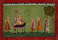
early 18th century Chamba princess
-
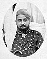
Gopal Singh, Raja of Chamba (ruled 1870–1873)

..jpg)
